Walk 3323 - printer friendly version
Gradbach, Three Shires Head & Knotbury Walk
Author - Lou Johnson
Length - 7.1 miles / 11.5 km
Ascent - 1000 feet / 303 metres
Grade - easy/mod
Start - OS grid reference SJ998662
Lat 53.1928860 + Long -2.0044500
Postcode SK17 0SU (approx. location only)
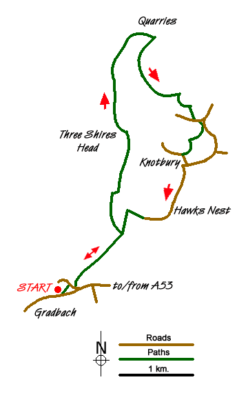
This Peak District walk visits three counties - Staffordshire, Cheshire and Derbyshire and offers an interesting walk in this fairly remote part of the National Park. The walk starts from the small car park near Gradbach (grid ref. SJ998662) which can be busy on fine days. There are no refreshments along the way so do make sure you have adequate food and drinks. Navigation is generally good although a 1:25000 OS map may help as there are many paths and tracks in this area.
Exit the car park and turn left along the lane or take the less obvious path from inside the car park that follows the river bank upstream. Turn left over the footbridge and walk across a field generally following the line of the river to another lane. You are now on the Dane Valley Way and this will be followed for much of the route. Stiles and gates generally have a DVW logo attached. Turn right along the lane and take the first left. This is a driveway to a house and you need to take the signed footpath that leads into a field. This path crosses a number of fields with a wall to your left. Continue until you reach a cast-iron footpath sign provided by the Peak & Northern Footpaths Society (grid ref. SK008670). Turn left here onto a track following the arrow pointing towards Three Shires Head. The path veers right off the track after 400 yards and climbs to a further track at grid ref. SK008677. The path for the last section up to this track is indistinct.
Bear left along the track descending slightly to reach Three Shires Head and two packhorse bridges over the River Dane (left) and a smaller stream coming in from the right. So far you have been in Staffordshire. As soon as you cross the smaller of the two bridges you step into Derbyshire and crossing the larger bridge will take you into Cheshire - hence the name of this location. To continue the walk cross both bridges into Cheshire. Once on the other side, turn right and continue upstream with the River Dane on your right. Stay with the Dane Valley Way which is the path closest to the river, passing below Holt Farm. The path is well signed and has some recent improvements and will take you up past a derelict building to a footpath junction below a disused chimney. Bear right here and follow the clear track through Danebower Quarry.
The path descends steeply to cross the River Dane, crossing into Derbyshire, before climbing up into Reeve-edge Quarry. The path soon becomes a track and easy to follow. The next section contours across the southern flank of a hill to pass above Blackclough down below on your right. The track loops into a side valley crossing a small stream to take you back into Staffordshire. Continue along the track towards Orchard Farm. You will see a gravel track snaking up to the farm on your right. The onward route bear left downhill here to reach the tarmac road at grid ref. SK019687. Bear left along the road, taking the first rough track on your right. This takes a shortcut and leads back to another tarmac lane. Almost immediately take the signed footpath on your right. This old walled lane leads across two fields to reach a high ladder stile. Cross this and bearing left continue until you reach the tarmac lane in Knotbury. Turn left down this lane to a T-junction. Turn right and follow the lane towards a steep sided valley. Bear left when the lane turns sharp left.
Continue along this lane past Hawk's Nest Farm on your right. The road reaches an area on your right where motor cycles scramble across the rocky hillside. Continue ahead on the lane passing through a gate to reach a house on your right. Go past the house and follow the track leading across field on your left. Turn left before the first wall, go into the next field, and walk half left to a small gate in the field corner. Go through the gate and ahead you will see the familiar sight of the cast-iron sign at grid ref. SK008670. All that remains is to follow your outward route back to the start perhaps enjoying the view ahead to the Roaches.
Messaging & Social Media
Message Walking Britain and follow the latest news.

Mountain Weather
Stay safe on the mountains with detailed weather forecasts - for iOS devices or for Android devices.