Cheriton Mill & Tichborne from Cheriton
Hampshire Walk
County/Area - Hampshire
Author - Lou Johnson
Length - 5.7 miles / 9.3 km Ascent - 300 feet / 91 metres
Time - 3 hours 10 minutes Grade - easy
Maps 

| Ordnance Survey Explorer OL32 | Sheet Map | 1:25k | BUY |
| Anquet OS Explorer OL32 | Digital Map | 1:25k | BUY |
| Ordnance Survey Landranger 185 | Sheet Map | 1:50k | BUY |
| Anquet OS Landranger 185 | Digital Map | 1:50k | BUY |
Walk Route Description
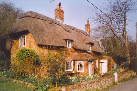
Click image to see photo description.
The start is the attractive village of Cheriton which lies to the east of Winchester. There is some on street parking in Cheriton by the village green, but please be mindful of local residents when parking. From the southern edge of the green walk west, cross the B3046 and follow Hill Houses Lane for a short way to take the Itchen Way, a signed footpath on your right. This leads across meadows to Cheriton Mill and a minor road (grid ref. SU579296). Turn right along the lane, cross the River Itchen and turn left at the crossroads with the B3046.
A short way along on your left, take the signed footpath, which goes half right across the field. You are still on the Itchen Way. This leads through a narrow belt of woodland continuing past Tichborne House on your left. Stay on the main track past the house. This continues into a wood bearing left to reach a junction opposite Vernal Farm (grid ref. SU572311). Turn left here and continue to a T-junction with a tarmac road.
Cross the road and take the path opposite (Itchen Way) to reach the corner of Trodd's Copse and a junction with the King's Way (grid ref. SU567309). Turn left here and follow the King's Way into the village of Tichborne. Reaching a road on a corner, turn right along a path leading to the church, which is worth a visit. Just before the church turn left. After a few yards turn right onto the King's Way which follows field boundaries until a signed path leads off left diagonally across field to join a track. Bear right along the track (signed bridleway) passing a small wood on your right.
Reaching a junction of bridleways (grid ref. SU560281), turn left and continue along the track to Hill Houses ignoring the bridleway on your right (Honey Lane). The track becomes a tarmac lane and leads you back to the B3046 and the centre of Cheriton.
Other walks nearby
| Walk 1964 | Abbotstone from Old Alresford | easy | 5.1 miles |
| Walk 1034 | Beacon and Old Winchester Hills on the South Downs | moderate | 10.5 miles |
| Walk 2662 | Beacon Hill and Warnford | easy/mod | 6.0 miles |
| Walk 2710 | Old Winchester Hill from Exton | easy/mod | 5.5 miles |
| Walk 2383 | Upham & Owslebury Circular | easy/mod | 6.5 miles |
| Walk 2459 | Upper Wield & Godsfield Circular | easy/mod | 6.7 miles |
| Walk 2533 | East Meon to Old Winchester Hill | moderate | 12.0 miles |
| Walk 2394 | East Meon & Wether Down | easy/mod | 8.0 miles |
| Walk 2373 | Hambledon Circular | easy/mod | 6.1 miles |
| Walk 1128 | Bradley & Burkham Circular | easy | 5.5 miles |
Recommended Books & eBooks
Walking Hampshire's Test Way
 Guidebook to walking the 71km (44 mile) Test Way in Hampshire from high on the chalk downs of Inkpen Beacon to the Eling Tide Mill near Southampton Water. Following the beautiful, crystal clear River Test, it passes picturesque villages and fascinating historic sites. Also includes 15 day walks to explore this lovely part of pastoral England.
More information
Messaging & Social Media
Message Walking Britain and follow the latest news.

Mountain Weather
Stay safe on the mountains with detailed weather forecasts - for iOS devices or for Android devices.