Walk 3332 - printer friendly version
Cameley & Hinton Blewett from Litton Walk
Author - Lou Johnson
Length - 5.6 miles / 9.1 km
Ascent - 300 feet / 91 metres
Grade - easy
Start - OS grid reference ST594546
Lat 51.2890770 + Long -2.5835931
Postcode BA3 4PW (approx. location only)
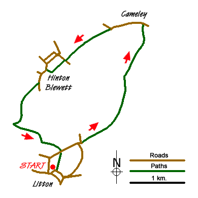
This pleasant walk through the Somerset countryside starts from the village of Litton (grid ref. ST594546) where there are a number of parking opportunities. However do respect residents' right of access and park considerately. As with many rural walks suitable footwear is necessary especially after wet weather.
From the village centre, walk towards the parish church and follow the footpath on its eastern side in a northerly direction. This leads you across a field, over the River Chew to reach Whitehouse Lane. Turn right along the lane passing Elm Tree Farm on your left to reach a road junction. Continue straight ahead here and join Hollow Marsh Lane, which can be muddy after rain. Follow the track to reach a T-junction (grid ref. ST607562) where you'll find a small wood on your right. Turn right here onto another track. In a few yards take the first footpath on your left. Turn left again a few yards and then almost immediately right onto a footpath that leads across fields to a road at Cameley (grid ref. ST611575).
Turn left along the lane, passing St James church on your right which is unspoilt and worth a visit. Continue west along the lane passing Church Farm on your right. Turn left onto the "Limestone Link" footpath on your left and continue across fields to follow the River Cam which is on your right. You reach a lane (grid ref. ST596568) where you turn right. Do not cross the River Cam, instead take the signed footpath on your left. This leads across fields to Combe Hill Farm where your turn right along the farm access track into the village of Hinton Blewett.
Turn left along the road to take the first lane on your left (Hook Lane). After about 200 yards, take the signed path on your right. This path leads across the western flank of Coley Hill and down to a reservoir (grid ref. ST586555). Turn left and take the path along the northern shore of Lower Reservoir continuing up to follow a similar path along the north-eastern shore of Upper Reservoir. This leads you back to Whitehouse Lane. Turn left and then almost immediately take the path on your right which leads you back to the centre of Litton village.
Messaging & Social Media
Message Walking Britain and follow the latest news.

Mountain Weather
Stay safe on the mountains with detailed weather forecasts - for iOS devices or for Android devices.