Walk 3340 - printer friendly version
Blea Moor & Denthead from Ribblehead Walk
Author - Lou Johnson
Length - 8.2 miles / 13.3 km
Ascent - 1100 feet / 333 metres
Grade - moderate
Start - OS grid reference SD766792
Lat 54.2080020 + Long -2.3602613
Postcode LA6 3JF (approx. location only)
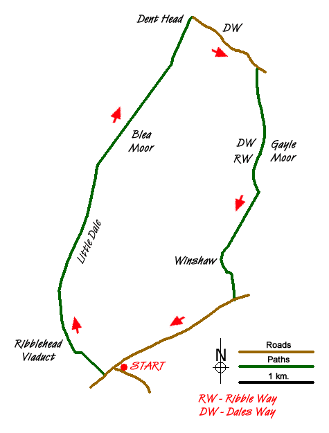
This Yorkshire Dales walk crosses some bleak landscapes, which for part of the way is shared by the Settle and Carlisle Railway. The route is generally easy to follow with a section of the Dales Way and Ribble Way joined for part of the route. The only disadvantage is some roadside walking on the final section. However there is open ground on this section so you can avoid walking on the tarmac.
The start is Ribblehead (grid ref. SD766792) where there are many opportunities for parking. Usually there is also a van serving refreshments. After parking take the often busy path running beneath the eastern side of Ribblehead Viaduct. Continue alongside the railway climbing gently passing Blea Moor signal box on your left. Reaching a junction (grid ref. SD760812) where the path to Whernside and Dent turns left across a railway bridge, keep straight ahead on a clear track.
Down to your left the railway enters Blea Moor Tunnel and the onward route follows the course of this tunnel across the moor passing the tunnel ventilation shafts that were so vital in the days of steam locomotives. The track soon starts to descend with views of Upper Dentdale and Great Knoutberry Hill opening up ahead of you. Just before you reach the northern portal of Blea Moor Tunnel, bear left where the track divides and drop down to Dent Head Farm. Turn right along their access road to a lane (grid ref. SD777843). Turn right. You are now on the Dales Way and you follow this road, climbing steadily.
Staying with the Dales Way, bear right onto a bridleway (grid ref. SD786836) that leads across Stoops Moss and onto Gayle Moor. The going is almost level before you start to descend into upper Ribbledale. Just before reaching a cross wall, follow the Dales Way as it turns sharp right (grid ref. SD786817). The Dales Way undulates across the hillside with High Gayle Farm below on your left. The path shadows the intake wall and where this turns left, the path follows suit dropping down to pass Winshaw and the B6255. Turn right along the road. You can avoid walking on tarmac as the road is unfenced on its northern side and you can cross the grassy slopes and under Runscar Scar using sheep trods and your own sense of direction back to the start. However do be careful on this section as there are old mine workings and sink holes.
Messaging & Social Media
Message Walking Britain and follow the latest news.

Mountain Weather
Stay safe on the mountains with detailed weather forecasts - for iOS devices or for Android devices.