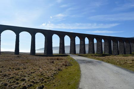
Blea Moor & Denthead from Ribblehead
Yorkshire Dales Walk
Nat Park - Yorkshire Dales - Three Peaks Country
County/Area - North Yorkshire & Cumbria
Author - Lou Johnson
Length - 8.2 miles / 13.3 km Ascent - 1100 feet / 333 metres
Time - 5 hours 10 minutes Grade - moderate
Walk Route Description
Click image to see photo description.
This Yorkshire Dales walk crosses some bleak landscapes, which for part of the way is shared by the Settle and Carlisle Railway. The route is generally easy to follow with a section of the Dales Way and Ribble Way joined for part of the route. The only disadvantage is some roadside walking on the final section. However there is open ground on this section so you can avoid walking on the tarmac.
The start is Ribblehead (grid ref. SD766792) where there are many opportunities for parking. Usually there is also a van serving refreshments. After parking take the often busy path running beneath the eastern side of Ribblehead Viaduct. Continue alongside the railway climbing gently passing Blea Moor signal box on your left. Reaching a junction (grid ref. SD760812) where the path to Whernside and Dent turns left across a railway bridge, keep straight ahead on a clear track.
Down to your left the railway enters Blea Moor Tunnel and the onward route follows the course of this tunnel across the moor passing the tunnel ventilation shafts that were so vital in the days of steam locomotives. The track soon starts to descend with views of Upper Dentdale and Great Knoutberry Hill opening up ahead of you. Just before you reach the northern portal of Blea Moor Tunnel, bear left where the track divides and drop down to Dent Head Farm. Turn right along their access road to a lane (grid ref. SD777843). Turn right. You are now on the Dales Way and you follow this road, climbing steadily.
Staying with the Dales Way, bear right onto a bridleway (grid ref. SD786836) that leads across Stoops Moss and onto Gayle Moor. The going is almost level before you start to descend into upper Ribbledale. Just before reaching a cross wall, follow the Dales Way as it turns sharp right (grid ref. SD786817). The Dales Way undulates across the hillside with High Gayle Farm below on your left. The path shadows the intake wall and where this turns left, the path follows suit dropping down to pass Winshaw and the B6255. Turn right along the road. You can avoid walking on tarmac as the road is unfenced on its northern side and you can cross the grassy slopes and under Runscar Scar using sheep trods and your own sense of direction back to the start. However do be careful on this section as there are old mine workings and sink holes.
Maps 

| Ordnance Survey Explorer OL2 | Sheet Map | 1:25k | BUY |
| Anquet OS Explorer OL2 | Digital Map | 1:25k | BUY |
| Ordnance Survey Digital Map Subscription | |||
| Latest Ordnance Survey Discounts | |||
Other walks nearby
| Walk 1208 | Ingleborough & Park Fell | moderate | 7.5 miles |
| Walk 3500 | Ingleborough (northern approach) | moderate | 9.5 miles |
| Walk 3032 | Gragareth & Great Coum from Yordas Cave | moderate | 9.0 miles |
| Walk 3135 | Dentdale & Bleamoor | moderate | 12.5 miles |
| Walk 1121 | Pen-y-ghent & Plover Hill | moderate | 9.0 miles |
| Walk 1013 | Pen-y-ghent | moderate | 6.5 miles |
| Walk 1500 | Pen-y-ghent via Horton Scar | moderate | 6.8 miles |
| Walk 3433 | Yorkshire Three Peaks | very hard | 24.5 miles |
| Walk 2146 | Deepdale Circular (near Dent) | moderate | 7.0 miles |
| Walk 1970 | Great Knoutberry Hill & Dent Head | moderate | 9.5 miles |
Recommended Books & eBooks
The Dales Way
 An essential guidebook to walking the Dales Way. This picturesque 78 mile long distance route through the Yorkshire Dales between Ilkley and Bowness on Windermere is one of the gentlest multi-day walks in Britain. The route is described in both directions, visiting Grassington, Kettlewell, Buckden, Dent, Sedbergh and Staveley en route to Bowness.
More information
Walking in the Yorkshire Dales: South and West
 Part of a two-book set, this guidebook describes 44 walks in the southern and western Yorkshire Dales, including the famous 23 mile Three Peaks circuit over Pen-y-Ghent, Whernside and Ingleborough. The other, mostly circular routes of 3½ to 13 miles cover the scenic region between Sedbergh, Kirkby Lonsdale, Settle, Skipton and Grassington.
More information
