Walk 3343 - printer friendly version
Hadrian's Wall, Walltown Crags & Aesica Walk
Author - Lou Johnson
Length - 5.0 miles / 8.1 km
Ascent - 770 feet / 233 metres
Grade - easy/mod
Start - OS grid reference NY675662
Lat 54.989321 + Long -2.5094471
Postcode CA8 7JD (approx. location only)
Hadrian's Wall runs for 73 miles across northern England and construction started in AD 122. The wall remained in use until the 5th century by which time the Romans had departed. Today there is still significant evidence of the wall with some sections restored or rebuilt to show their impregnable and intimidating construction. This walk includes one of the best preserved sections of Hadrian's Wall to the north of Haltwhistle.
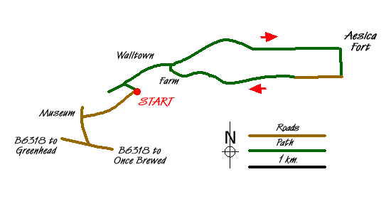
The start is a small car park (Grid ref NY675662), which is reached by taking the B6318 east from Greenhead and taking the first left turn to the Wall and Roman Army Museum. Just opposite the Museum turn right down a narrow tarmac lane. The parking area is on the left just before a sign restricting further access to the lane. After parking, walk up the grass slope. Reaching one of the best preserved sections of the wall, it worth spending a few minutes and walking west (turning left) along the wall to overlook the large quarry before retracing your steps and continuing along the wall in an eastward direction.
The path follows the wall and it is difficult to lose your way. Passing Walltown Quarry you will soon realise that the wall follows an undulating route and that there are plenty of ups and downs to this walk. Just after Walltown Quarry you reach Milecastle 45. These intermediate fortifications were spread along the wall every Roman Mile and offered access through the wall and additional fortifications. You will have noticed that evidence of the wall gradually reduces and in places the remains are very sparse. Reaching Great Chesters Farm you can investigate the site of Aesica Roman Fort where remains of buildings and a shrine are easily seen.
The walk leaves the wall here. Turn right down the track towards the road. At the first junction (Grid ref. NY704664) turn right and follow a clear track. This track follows the course of the Vallum, an auxiliary defensive ditch. Stay on this track to just before Walltown Farm. Here turn right and on reaching the wall, turn left and return along the wall back to the start.
Messaging & Social Media
Message Walking Britain and follow the latest news.

Mountain Weather
Stay safe on the mountains with detailed weather forecasts - for iOS devices or for Android devices.