Walk 3350 - printer friendly version
Kinder Scout Summit Walk
Author - Jake Robertson
Length - 8.5 miles / 13.8 km
Ascent - 1800 feet / 545 metres
Grade - moderate
Start - OS grid reference SK124853
Lat 53.364428 + Long -1.8151258
Postcode S33 7ZQ (approx. location only)
Though one of England's most popular and important mountains, the 2088ft summit of Kinder Scout is an unfrequented place due its boggy nature. However, this direct route is well worth doing, an exciting and little done scramble onto the plateau and a dramatic descent, it should bring out another aspect of the mountain. Because of its fragile nature of the terrain, this route is best done either on your own or in small groups.
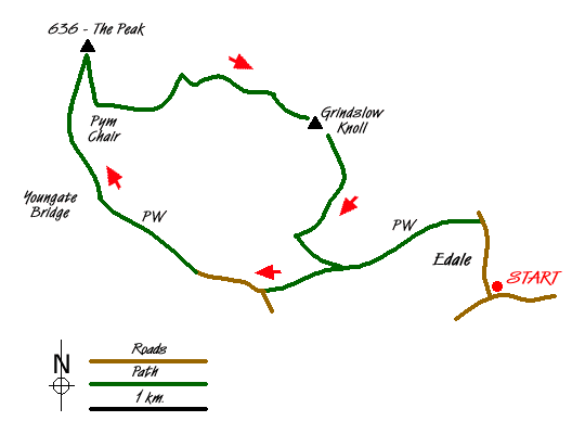
To start this Peak District walk, leave the main car park at Edale (Grid ref. SK124853) and walk up the road into the village. Join the Pennine Way on the left just past the post office. Well signposted, this gives an easy and dramatic walk up the valley as far as Youngate Bridge at the foot of Jacob's Ladder (Grid ref. SK088861).
Leave the Pennine Way and head up the stream on its east bank. Suddenly the place is very quiet, only the sound of waterfalls breaks the silence. Keep with the stream until you reach a large confluence with a stream dropping down from the north. This is the stream that flows from the summit.
Progress up the clough is quite hard, waterfalls force you to make steep climbs around them and the tightness of the clough gives little room for manoeuvre. Higher up the stream a rocky bed makes going easier. A delightful scramble up the rocky bed and small waterfalls leads to the main edges path near Noe Stool.
A different world is entered as you go north up a grough onto the plateau. When it becomes to tight, climb out onto the moor. Ahead should be a cairn and a stake, reached by a short walk over the bogs. The summit (known as The Peak) is wild, wet place with excellent views over the Peak District, you really feel on top of the world (Grid ref. SK085875).
The safest way out of the bogs is to make a direct line for Pym Chair then go to the nearby Pagoda. A clear (if badly eroded) path heads through the fascinating Woolpacks to the top of Crowden Tower (2030ft) then drops steeply to the head of Crowden Clough Grid ref. SK094872), a super view. Climb up on a clear path over the moor to a rocky outcrop on the crest. Take a reasonably dry path over a subsidiary top to the 1970ft summit of Grindslow Knoll, one of my favourite hills.
Though the normal way to Edale goes down the long east slope, it is a nice alternative to descend the south ridge and follow a path over the moor past two small pools (Grid ref. SK110862). As you gain the top of Broadlee Bank swing west to the lip of the moor. The path makes a swift but very steep descent down to the Pennine Way, though the grand view of Kinder and Lord's Seat takes away some of the pain. From the Pennine Way, retrace you steps back into Edale.
A few interesting facts about the summit. There are 3 points which reach 2088ft, the one with the cairn and stake is accepted as the top. Its name is also a mystery, called The Peak, Edale Head and Point 636 by some. I myself prefer to call it The Peak. Also, it is the highest ground in England south of Fountains Fell, over 50 miles away.
Messaging & Social Media
Message Walking Britain and follow the latest news.

Mountain Weather
Stay safe on the mountains with detailed weather forecasts - for iOS devices or for Android devices.