The Stackpole Estate from Stackpole Quay
Pembrokeshire Coast Walk
Nat Park - Pembrokeshire Coast
County/Area - Pembrokeshire
Author - Lou Johnson
Length - 5.0 miles / 8.1 km Ascent - 600 feet / 182 metres
Time - 3 hours 10 minutes Grade - easy
Maps 

| Ordnance Survey Explorer OL36 | Sheet Map | 1:25k | BUY |
| Anquet OS Explorer OL36 | Digital Map | 1:25k | BUY |
Walk Route Description
Click image to see photo description.
A varied Pembrokeshire walk exploring the Stackpole Estate that begins from the tiny harbour at Stackpole Quay. The route then continues along the Pembrokeshire Coast Path following the cliffs to Barafundle Bay. The walk continues around Stackpole Head with the coastline becoming more dramatic with stacks, natural arches, and blowholes. After a short section across the sands at Broad Haven, the route follows the banks of the Bosherston Lily Ponds before crossing fields back to the start.
The start is National Trust carpark at Stackpole Quay (grid ref. SR991958). After parking descend to the small harbour, which is worth a few minutes' exploration. To continue join the Pembrokeshire Coast Path which starts by climbing a flight of steps. After passing through a gate you reach the cliff tops with a clear path leading to Barafundle Bay.
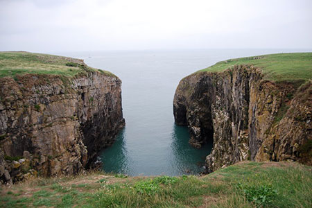
The path descends through an arch and down steps to the beach. Head across the beach to a short flight of steps on the far side. Continue through trees to a gate and open grass on the cliff top. You soon have a good view back to Barafundle Bay. The best option is to follow the paths close to the cliff tops as this enables you to see the many interesting features in this area including several natural arches. Continue along the cliffs to reach rocky Stackpole Head from where you can enjoy a fine view along the coast in both directions.
On the next section you pass several blowholes at various stages of development with the path skirting around rocky coves. After a section of easy walking the path follows the cliffs around Saddle Point with the beautiful beach at Broad Haven coming into view. Pass through the gate and follow the path along the dunes. You soon have a glimpse ahead of the Lily Ponds. Reaching a three-way fingerpost, turn right and follow the clear path ahead signed to Bosherston. Glimpses of the lily pools on your left before passing into trees. Cross a causeway and then turn right and follow the path on the west side of the northern arm to reach an arched bridge.
Cross the bridge, pass through a gate, and follow the track between fields. Keep straight ahead ignoring tracks to the right and left. The track leads to a gate and the car park.
Other walks nearby
| Walk 3366 | Bosherston Lily Ponds | easy | 3.4 miles |
| Walk 3365 | Bosherston Lily Ponds, Broad Haven & St. Govan's Chapel | easy/mod | 5.0 miles |
| Walk 3495 | St. Govan's Chapel, Bosherston & Elegug Stacks | moderate | 9.6 miles |
| Walk 3363 | Swanlake Bay from Manorbier | easy/mod | 4.8 miles |
| Walk 3498 | Freshwater West & Angle | moderate | 8.7 miles |
| Walk 3475 | Caldey Island Circular | easy | 3.0 miles |
| Walk 3497 | Angle Peninsula | easy | 3.7 miles |
| Walk 1209 | Saundersfoot & Tenby | easy/mod | 4.5 miles |
| Walk 3496 | St Anne's Head & Dale Peninsula | easy/mod | 7.0 miles |
| Walk 2485 | Broad Haven & Druidston Circular | easy/mod | 4.9 miles |
Recommended Books & eBooks
The Wales Coast Path
 A single guidebook to walking the whole Wales Coast Path - 1400km (870 miles) the length of Wales from Chester to Chepstow, including Anglesey, described in 57 stages. The route passes through the Snowdonia and Pembrokeshire National Parks and many AONBs and can be linked with the Offa's Dyke Path for a complete circuit of Wales.
More information
Messaging & Social Media
Message Walking Britain and follow the latest news.

Mountain Weather
Stay safe on the mountains with detailed weather forecasts - for iOS devices or for Android devices.