Walk 3391 - printer friendly version
Valley of Rocks frrom Lynton Walk
Author - Lou Johnson
Length - 3.8 miles / 6.2 km
Ascent - 900 feet / 273 metres
Grade - easy/mod
Start - OS grid reference SS721493
Lat 51.2285160 + Long -3.8331349
Postcode EX35 6JD (approx. location only)
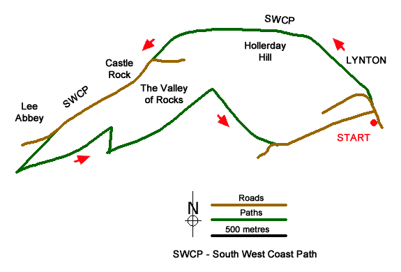
This walk explores the Valley of Rocks from Lynton in North Devon. The route explores a short section of coast and the dramatic scenery immediately inland. The walk uses well-trodden paths and provides some excellent views especially across the Valley of Rocks and the adjacent coast. Along the way you may encounter some of the wild goats that live in this area!
The start is the pay and display Bottom Meadow car park on the west side of Castle Hill in Lynton. After parking exit the car park and turn left onto Castle Hill. Continue along the road to reach St Mary the Virgin Church on your right. Just past the church bear right into North Walk Hill. There is a sign on your right confirming the footpath to Valley of Rocks. Follow the lane as it bends to the left to join the South West Coast Path. On your right you can enjoy the view across to Lynmouth and the high cliffs beyond.
The lane eventually becomes a wide path and soon enters open ground. To your left is Hollerday Hill with its outcrops of rock. The path is easy to follow and as you progress Castle Rock appears ahead. Reaching a road (grid ref. SS705497) at a roundabout, go straight across and follow the grassy path through bracken on the right-hand side of the road. At the first fork in the path, bear left and continue along the South West Coast Path with the road close by on your left. There is a nice view to the sea on your right. The path eventually joins the road. Continue through the gate by the cattle grid, continue past the entrance to Lee Abbey to reach a stone archway on your right.
At this point bear left up a track with a footpath fingerpost. Continue up the track into woodland. After 400 metres, turn sharp left at the first footpath junction. The path soon leaves the wood and enters open country. Follow the path ahead which soon turns sharp right to cross the hillside at an angle. Shortly after the path turns sharp left and completes the climb onto South Cleave from where you have a bird's eye view of the Valley of Rocks below on your left and an excellent view across Lynton to the Exmoor Hills beyond.
The clear path descends and then bears right soon becoming a wider track which leads down to Lydiate Lane. Bear left and follow the lane down to join Station Hill at a bend. Continue ahead still following Lydiate Lane into Lynton ignoring all side roads. As you enter an area with some shops, bear right down the road signed to "Main Road and Public Conveniences". Follow this road past the Lyn and Exmoor Museum (on your left), Continue along the road which bears to the right past a school. Bear right onto Castle Hill and the car park used at the start is on your right.
Messaging & Social Media
Message Walking Britain and follow the latest news.

Mountain Weather
Stay safe on the mountains with detailed weather forecasts - for iOS devices or for Android devices.