Walk 3395 - printer friendly version
The Stiperstones Ridge Walk
Author - Lou Johnson
Length - 5.5 miles / 8.9 km
Ascent - 660 feet / 200 metres
Grade - easy/mod
Start - OS grid reference SO369976
Lat 52.572543 + Long -2.9324883
Postcode SY5 0NL (approx. location only)
This walk includes the majority of the main path that runs the length of Stiperstones Ridge. Rising to 536 metres, the quartzite outcrops that are characteristic of this Shropshire hill offer excellent vantage points for views across the surrounding countryside including the Long Mynd, Corndon Hill and mid-Wales. The rugged nature of this the second highest hill in Shropshire adds scenic interest to upland heather moors that cover the high ground of the ridge. The Stiperstones Ridge is a National Nature Reserve and lies within the Shropshire Hills AONB.
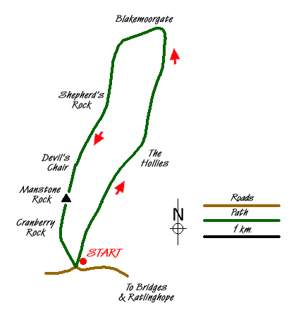
The start for this walk is the Knolls Car Park (grid ref SO369976). Here an information board illustrates the geology and wildlife of the Stiperstones. Do not go through the gate leading directly to the Stiperstones but instead exit the car park at its northern end and follow the bridleway. This leads through Gatten Plantation to reach a junction of tracks above the Hollies (grid ref SO376991). Go straight across here and ignore the left fork a few metres further on. At the next junction (Grid ref. SO378994) bear left and then continue ahead following a path (not marked as a right of way on OS maps) that rises slowly across the hillside. Some route finding may be necessary on this section although the path was generally clear on the ground when this walk was researched.
Joining a bridleway (Grid ref. SJ379001), follow this north with pleasant views opening up ahead as it contours around the northern end of the Stiperstones Ridge. At a junction of tracks (Grid ref. SJ380011) bear left and start to climb above Blakemore Gate. At the next junction bear left and start to climb more energetically. This path climbs steadily towards the Shepherd's Rock and continues on the main Stiperstones ridge path climbing gently towards the Devil's Chair and Manstone Rock.
The views are now superb. On your right you are able to see the deep steep-sided valleys that cut into the ridge. Further afield the views extend into mid-Wales. The path becomes quite rocky underfoot and progress slows. However you soon arrive at Manstone Rock with its concrete trig column. This is the highest point on the Stiperstones ridge (536 m). Staying with the main ridge path you start to descend with the option of making a short diversion to the Cranberry Rock. Soon the path reaches the Knolls car park and the end of the walk.
Messaging & Social Media
Message Walking Britain and follow the latest news.

Mountain Weather
Stay safe on the mountains with detailed weather forecasts - for iOS devices or for Android devices.