Walk 3435 - printer friendly version
Keeper's Pond & Blorenge Walk
Author - Lou Johnson
Length - 7.5 miles / 12.2 km
Ascent - 1400 feet / 424 metres
Grade - easy/mod
Start - OS grid reference SO284109
Lat 51.7921510 + Long -3.0395477
Postcode NP7 9LE (approx. location only)
Blorenge is an isolated hill lying south of Abergavenny in Monmouthshire. The hill affords fine views especially to the north with Abergavenny's other popular hill the Sugar Loaf just a few miles away. In addition, the panorama includes some of the higher summits of the Brecon Beacons National Park.
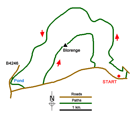
The start of the walk is a small car park on the north side of the lane leading across the southern flank of Blorenge at grid ref. SO284109. This can be reached from the B4246 at Pen-fford-goch pond, which will be passed during the walk and where alternative parking is available. After parking, head east along the lane descending steeply. Where the lane turns sharp right, take the track on your left and follow this through to a lane (grid ref. SO288110). Turn left along this lane and after 300 metres turn sharp left (ignoring the drive to Upper Ninta) and follow a rising track to reach a junction of tracks (grid ref. SO 282113).
Go right through the gate descending to pass a small lake in the Punchbowl. The onward route continues and contours Blorenge to pass Cwm Craf. The onward route continues along the northern flank of Blorenge to a junction of paths and tracks at grid ref. SO269128) with a plantation on your right. Bear left here following the path to Keeper's Pond (Pen-fford-goch Pond) which will be on the left of the path. Continue along the edge of the pond towards the car park. At the southern end of the pond bear left onto a grassy path heading east to reach a lane (grid ref. SO258106).
Bear left along the lane across the moorland and follow it as far as the Foxhunter car park and the WT station marked on OS maps (grid ref. SO263107). Turn left and follow the clear path to the summit of Blorenge which is home to a customary trig column. Take time to enjoy the view especially to the north before following the path initially heading northeast to reach the escarpment edge (grid ref. SO27712) from where you can look down on Abergavenny. Here the path turns south and leads to the moorland lane (grid ref. SO278112). Turn left over the cattle grid and walk down the lane back to the start.
Messaging & Social Media
Message Walking Britain and follow the latest news.

Mountain Weather
Stay safe on the mountains with detailed weather forecasts - for iOS devices or for Android devices.