Walk 3436 - printer friendly version
Hillsborough to Bradfield & Loxley Valley Walk
Author - Andy Chaplin
Length - 12.6 miles / 20.5 km
Ascent - 1100 feet / 333 metres
Grade - moderate
Start - OS grid reference SK330905
Lat 53.4102870 + Long -1.5050320
Postcode S6 1TG (approx. location only)
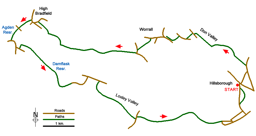
Whereas Walk 3330 covered part of the Rivelin valley as it comes from Malin Bridge and Hillsborough on the north west of Sheffield, this walk follows parts of the Don and Loxley valleys north and west from Hillsborough. As with No 3330 it is possible to start and finish at Supertram stops which makes the walk easy from any part of Sheffield although it does mean there will be some city-walking.
Starting at the Leppings Lane tram stop (grid ref. SK330905), which is actually on Middlewood Road, walk north east down Leppings Lane over the river Don and past the Sheffield Wednesday football ground. At Penistone Road turn left then first left again around the back of Carphone Warehouse on Beeley Wood Road. This leads onto Clay Wheels Lane which is the start of the less-urban walking. You pass Sainsburys and the Fletchers bakery on the right, which was partly destroyed by a fire in 2006, and then pick up the river Don on your left. This is your last chance to do any supermarket or mobile phone shopping.
When the Claywheels Lane/Beeley Wood Lane comes to an end at the Abbey Group works take the path on the left which goes around the factory then cross on the Rocher Bridge over the Don. Take the path straight up to Middlewood road, turn right on the road, cross over, then take the path on the opposite side of the road. This is now part of Bradfield Parish Council (BPC) where many of the paths are numbered. This one (BPC 148) goes up to Stockarth Lane.
Walk up the lane heading north then take the first bridleway off on the left (Fleet Lane - BPC 51) and follow it to just below Worrall Lane. There is a footpath off here to the right which runs parallel to the road and comes out in Worrall Recreation Ground.
From Worrall Road turn left onto Kirk Edge Road and take the path on the left which is just after the last houses after Kirk Edge Drive. This is the part of the Sheffield Country Walk (SCW). It angles over three fields and passes behind a water treatment building before making its way towards Low Ash Farm on Darwent Lane. Go right when you go over the wall/stile in front of the farm then left down the lane.
At the corner take the track heading west (BPC 46). This is still the SCW and it continues along the track, turns off left below Haighenfield Farm and then crosses fields until it reaches Holdworth Lane. There are good views now to the south into the Loxley valley. The SCW goes right on Holdworth Lane and takes the second left on Moor Road. Shortly after this you take the path on the right (BPC 38) and follow it past Holdworth Hall, New Lathes and Cliffe House Farm. Just before the Loxley Road the path goes uphill to the right and comes into High Bradfield over Castle Hill. The Bradfield Brewery is in the farm on your left - be warned, you are now entering Bradfield beer-country and several pubs lie on the next part of the route.
In Bradfield, go past the Old Horns Inn towards the church then turn off left just before the church gates. There are a couple of new markers to graves of victims of the 1864 Dale Dyke flood in the churchyard which are worth a detour. The path (BPC35) goes around the south of the churchyard then heads across country towards Low Bradfield. Cross Smallfield Lane and stay on the BPC35 path as it follows the stream from Agden Reservoir and comes out by a car park, sports area and then onto The Sands.
Cross the Dale Dike on Mill Lee Road, pass the Plough Inn on New Road then turn off left towards School Bridge and the head of the Damflask Reservoir. Follow the permissive path all the way around the south bank of the reservoir then take the road across the dam wall and turn right along Loxley Road to Stacey Bank. Just before the Nags Head turn down Stacey Lane to the river Loxley then take the path along the valley.
The path follows the river and passes the Loxley fisheries, the old Dyson refractories works and several mill ponds and weirs. A description of the mills and ponds is available in "A Report to The Don Catchment Rivers Trust" (use Google search) and the map/summary may be worth taking for those interested in industrial history. The path stays to the north of the river, crosses Rowel lane then continues along the north bank all the way to the Loxley Road at Malin Bridge. There is a tram stop here or it is another mile to complete the circuit and walk back through Hillsborough and Hillsborough Park to Leppings Lane.
Messaging & Social Media
Message Walking Britain and follow the latest news.

Mountain Weather
Stay safe on the mountains with detailed weather forecasts - for iOS devices or for Android devices.