Walk 3439 - printer friendly version
High Bradfield from Glen Howe Walk
Author - Andy Chaplin
Length - 8.3 miles / 13.5 km
Ascent - 1500 feet / 455 metres
Grade - moderate
Start - OS grid reference SK296943
Lat 53.4446430 + Long -1.5558222
Postcode S35 0EP (approx. location only)
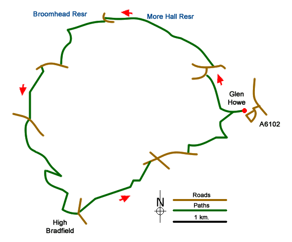
This Peak District walk starts at the car park opposite Glen Howe park which is an area of land donated to the people of Wharncliffe Side in 1917. Along the way there are great views into the Ewden and Dale Dike valleys, two grade 2 listed Halls and Bradfield church and watch house. The car park, (grid ref. 296943 is at the end of a narrow road, Storth Lane, and the entrance to the park is just opposite at the side of Tinker Brook.
The park is a lovely wooded valley. Walk up the road past the tower house and information board, take paths up to and then over the packhorse bridge, then find the exit over a stile at grid ref. SK292944, which is up on the north side of the valley.
Take the path across the fields up to Swinnock Hall, a Grade 2 listed building, then down the track, Swinnock Lane, to the Brightholmlee Road. Turn right then right again into the hamlet of Brightholmlee. Just past the Grade 2 listed Old Hall farmhouse there is a path (No 115) that goes down a track, Old Field Lane, then a path to More Hall Reservoir.
Follow the permissive path along the south bank of the reservoir and keep going until you reach the road - Jack Lane at New Mill Bank. Turn left then first right onto the track that goes up at the side of Broomhead reservoir. At grid ref. SK267958 take the path up the hill and through the trees to the New Road at the top. Go straight over and take the path - No 156 - through Poggs Wood to Walker Edge road. Turn right here and a little further on there is a bench with a great view over the reservoirs and Ewden valley.
A little further along go over the stile on the left - path No 157 - and follow the path along the western edge of White Lee Moor. You come out at Penistone Road, cross straight over and follow the path south then south east along Rocher Top. You now have views into the Agden reservoir valley. When the path narrows then reaches a farm track, turn right to go downhill then as you come out of the trees turn left and keep left as you join another path from the right. There are several paths here as you approach the wood at Rocher End but ignore one that goes into Oaking Wood, cross over the Rocher End brook then head east and south to come out of the trees just below Bailey Hill.
Take the path towards High Bradfield church. The church, flood graves and watch house are well worth investigating then come out north of the churchyard on Jane Street. Cross straight over onto path No 35 and follow it uphill out of Bradfield across fields then past the Kirk Edge moorland and the Onesmoor transmitter on your right. The path comes out on Lumb Lane.
At the road junction go straight on taking Lumb Lane until you turn off left on path No 102 which goes down to Hill House farm. Turn left before the farm, follow the path into the wood above Foldrings and stay on the slightly neglected route until it comes out on Raynor Syke Lane. Turn right on the lane then left down a road opposite Acre Lane.
The path here goes on the road in front of the houses before going off right between out-buildings then across the fields towards the trees of Glen Howe park. The stile into the park is at grid ref. SK292941 which is about half way along the side of the final field that you cross. In Glen Howe park find paths downhill towards the Tower house then out on the road to the car park.
Messaging & Social Media
Message Walking Britain and follow the latest news.

Mountain Weather
Stay safe on the mountains with detailed weather forecasts - for iOS devices or for Android devices.