Walk 3442 - printer friendly version
Haws Hill from Tenbury Wells Walk
Author - Lou Johnson
Length - 6.6 miles / 10.7 km
Ascent - 500 feet / 152 metres
Grade - easy/mod
Start - OS grid reference SO595680
Lat 52.3086100 + Long -2.5954452
Postcode WR15 8EH (approx. location only)
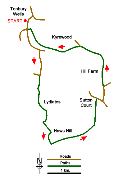
This Worcestershire walk starts from the town of Tenbury Wells which lies on the River Teme. This route heads south across attractive countryside to Haws Hill before continuing through a pastoral landscape to follow Kyre Brook back to the start. The long stay car park A convenient place to park is along Pembroke Avenue on the east side of the A4112 to Leominster near the junction with the B4214 to Bromyard (grid ref.SO595680).
After parking, follow the B4214 out of town for 800 metres and turn right along Terrills Lane (grid ref. SO597673). Continue along the lane for 700 metres to a junction. Go straight across following the track signed to Lydiates Farm. Where the track bends left to Lydiates Farm, turn right along the field edge, go through gap and then follow the left-hand field boundary down to a wooded valley. Turn right and then left across a stream and continue into a field keeping the boundary on your left. Walk through small wood and continue in field with boundary to your left. Bead right past pool and Frith Farm (grid ref. SO599653). Turn left into a field and walk uphill with boundary to your left. Entering woodland veer right and climb the side of Haws Hill.
Exiting the wood, turn left and go through a gate. Turn right along the field edge. Reaching the corner, turn left and cross the top of Haws Hill. Pass pond on your right and continue straight ahead in next field. Keep to the left of a group of trees to join a clear track. After 800 metres along the track take the footpath on the left (grid ref. SO613653). The path crosses a large field and then a smaller to reach the B4214 at a stile (grid ref. SO613660). Turn right and take the first lane on the left. Where lane turns sharp right, continue ahead through meatal gate onto the drive to Hill Farm. Reaching the farm, take the gate on the right and continue through orchards. In the second orchard aim for the bottom left hand corner and continue into a field. Drop down to a footbridge over Kyre Brook.
After crossing the bridge bear half left across a field. Pass through a small nature reserve, pass cottages and Brook Farm to join a clear access track (White House Lane). Turn left onto a path opposite a bungalow (grid ref. SO609674). Bear right along the edge of the orchard to continue on an eroded path across a steep bank. Continue into a sloping field and head uphill to a gate below an oak tree. The path continues through a garden (with house on right) to a field. Cross a tile on your left, then head right across the field with a house on the hill to your right. Cross a track and pick up a well-trodden path across fields with the Kyre Brook on your left. Reaching a T-junction of paths (grid ref. SO595679), turn left and continue to Pembroke Hose. Bear right and the start is a short walk away.
Messaging & Social Media
Message Walking Britain and follow the latest news.

Mountain Weather
Stay safe on the mountains with detailed weather forecasts - for iOS devices or for Android devices.