Walk 3445 - printer friendly version
The Dragon's Back (Chrome Hill) from Hollinsclough Walk
Author - Daryl Smith
Length - 4.5 miles / 7.3 km
Ascent - 1050 feet / 318 metres
Grade - moderate
Start - OS grid reference SK065665
Lat 53.1955440 + Long -1.9041640
Postcode SK17 0RH (approx. location only)
This may be a short Peak District walk but it packs in magnificent views and a traverse of the dramatic "Dragon's Back" of Chrome and Parkhouse Hills.
The tiny Staffordshire Moorlands hamlet of Hollinsclough has only limited parking space and there are no public facilities. The walk can easily be extended by parking in nearby Longnor, an attractive village with public toilets, cafes, small shop, art gallery and at least one good pub! Approaching Hollinsclough along the very quiet lane from Longnor affords inspiring views of hills to be climbed.
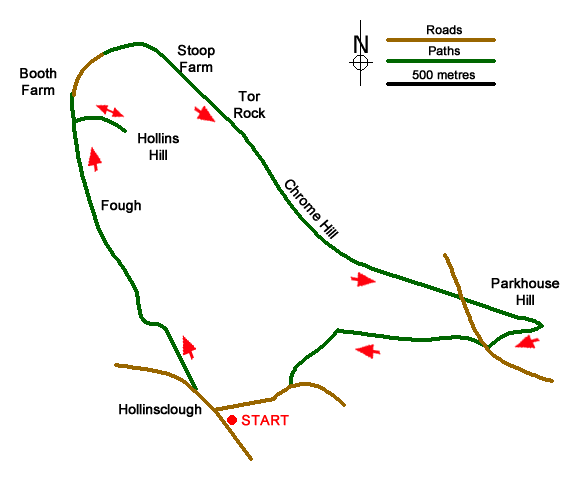
Leave Hollinsclough on the lane to the left of the chapel and then take the first path on the right at the side of a stone barn. Follow the path diagonally across the valley and turn left on a farm track. A public right-of-way follows this track along the flank of Hollins Hill all the way to Booth Farm. When Booth Farm comes into sight ahead you are in open access land; make your way up to the high point of Hollins Hill where you will be rewarded with a truly spectacular view of Chrome Hill.
Return to the track and continue past Booth Farm along the lane then over a stile and follow the path as it loops above Stoop Farm, at the farm entrance by a cattle grid leave the right-of-way onto a clearly signed concessionary path past Tor Rock then down to the north-eastern end of Chrome Hill. Traverse the ridges of Chrome and Parkhouse Hills with superb views of both limestone and gritstone country; the line of coral reef limestone forming the hills is clearly visible.
(Note: A direct ascent of Parkhouse Hill on its ridge line can be slippery and has a fair degree of exposure; in wet and windy conditions it may be best to walk up the grassy slope on the left as you approach, at the top of that slope go up to the ridge and then explore the pinnacles and views from that point.)
Descending from the ridge of Parkhouse, contour right below the trees and you will see a track ahead through the pillared entrance to Stannery, simply follow the track for an easy stroll back to Hollinsclough. If you have walked from Longnor you could head left from the hillside to a path over a footbridge and back to the village.
Messaging & Social Media
Message Walking Britain and follow the latest news.

Mountain Weather
Stay safe on the mountains with detailed weather forecasts - for iOS devices or for Android devices.