Walk 3453 - printer friendly version
Whinfell Beacon & Borrowdale Walk
Author - Lou Johnson
Length - 8.4 miles / 13.7 km
Ascent - 1700 feet / 515 metres
Grade - moderate
Start - OS grid reference NY552038
Lat 54.4276420 + Long -2.6920422
Postcode LA8 9LG (approx. location only)
This circular walk lies near the eastern boundary of the Lake District National Park. The route crosses a quiet undulating ridge to reach Whinfell Beacon before descending into Borrowdale (not the well-known dale) and a quiet return to the start. The initial ascent is steep but once the ridge has been gained, you can enjoy a quiet day walking in excellent scenery. The views include the Pennines, the Howgills, the Lake District Fells and Morecambe Bay. It is unlikely you will see other walkers although careful navigation is required in places.
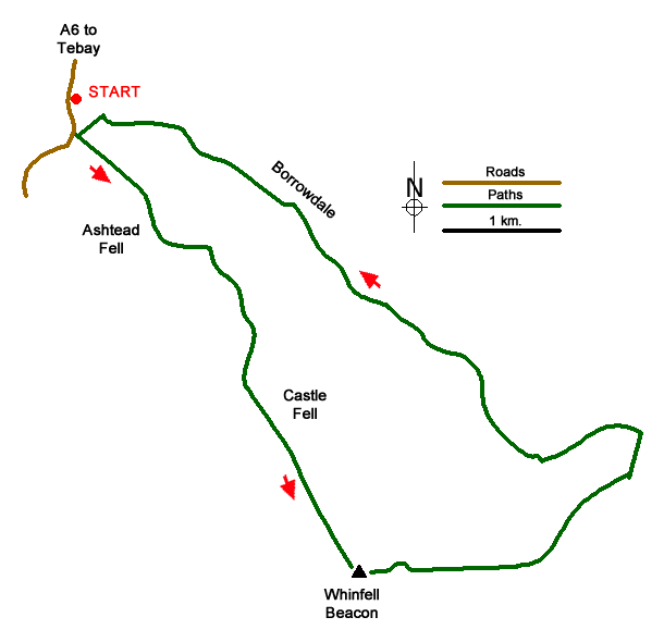
The start is the layby just south of Huck's Bridge on the A6 (grid ref. NY552038) about 8 miles south of Shap village. After parking walk south along the A6 and take the signed track on the left just where the A6 bends to the right. Go through the gate and immediately turn right on a path heading steeply uphill. Continue following the path (feint in places) to reach the cairn on Ashstead Fell (grid ref. NY557030). Catch your breath and enjoy the view west to the Lake District Fells. Continue downhill and up to the true summit 400 metres southeast of the cairn.
The path veers east to a further unnamed summit from where a view into Borrowdale can be enjoyed. Descend south aiming for the gap in the plantations continuing to follow the path uphill veering right as you reach open ground to the cairn on Mabbin Fell, the highest point of the walk. Stay on the descending path soon passing a small stone building. You then enter forest heading southwest. On exiting the trees bear half right to cross a fence by a dilapidated stile. Walk southeast to cross a ladder stile. Stay with the wall on your right. Go through a gate and head uphill along an intermittent path. Cross the stile in the wall and continue the short distance to the shelter and cairn on Whinfell Beacon (grid ref. NY573003).
To continue, head east on a descending path to a ladder stile. After crossing the stile bear half left and continue in an easterly direction. Where the path forks (can be easily missed) bear left and cross a stile. Reaching a service road (grid ref. NY584002), turn left and continue past a gate of the first telecom compound. Just before the access track starts to climb to the higher compound, near left to join a bridleway. Follow this grassy path down into Borrowdale.
Turn left along the valley track beside Borrow Beck. Continue to Low Borrowdale Farm. Take the gate to the left of the farmhouse. Keep left to a second gate and join a fenced track. Continue up the valley to pass abandoned High Borrowdale Farm. Just over half a kilometre from High Borrowdale, cross Borrowdale Beck via a bridge and continue along the track back towards the A6. Reaching a fork (grid ref. NY555037), bear left and regain the A6. Turn right back to the start.
Messaging & Social Media
Message Walking Britain and follow the latest news.

Mountain Weather
Stay safe on the mountains with detailed weather forecasts - for iOS devices or for Android devices.