Corton Denham and Cadbury Castle
Somerset Walk
County/Area - Somerset
Author - Lou Johnson
Length - 6.7 miles / 10.9 km Ascent - 800 feet / 242 metres
Time - 4 hours 10 minutes Grade - easy/mod
Walk Route Description
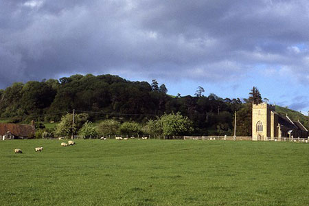
Click image to see photo description.
This Somerset walk features the Iron Age hillfort of Cadbury Castle and the surrounding countryside. The area is characterised by long ridges of hills which provide shelter to the valleys below with picturesque villages which are worth exploring. The start is the car park for Cadbury Castle (grid ref. ST632253) which is located on the south side of the village of South Cadbury. Access is from the A303 some five miles west of Wincanton.
After parking turn left along the lane. Continue to Crangs Lane and turn right. Take the signed footpath on the left after 100 metres (grid ref. ST633249). Continue south on the footpath and cross a track and barn on your left to reach a path junction after 500 metres. Take the left-hand fork and continue along the foot of a hill on your left. Continue along the left-hand edge of a large field. Reaching the end of the field, turn right and continue to Whitcombe Farm (grid ref. ST634238).
Follow the farm access drive for 400 metres to a road. Turn left and continue between two hills to reach a signed footpath on the left. Take this path which runs below the western slope of the Beacon and Corton Hill (on your left). Continue along the path to reach a road at the northern end of the village of Corton Denham. If you turn left (south) then the Queen's Arms is a short walk into the village. To continue the walk, turn right (north). After 200 metres turn left into Ridge Lane (just past the last house on the left).
Initially a tarmac lane, Ridge Lane becomes an unsurfaced bridleway and rises gently onto Corton Ridge. Reaching a cross path on the ridge, turn right and follow the Monarch's Way north for 1.5 kilometres. The path descends across the west flank of Parrock Hill to reach a road (Kember's Hill). Turn left and immediately right along the road signed to South Cadbury. After 150 metres turn left into Buckland Lane. This lane bends right, left, and then right again and leads to a road at Sutton Montis (grid ref. ST626246).
Turn left into the village. At the next T-junction turn right signed to Little Weston. Continue past the Parish Church on your left, follow the road as it bends left. Continue for 600 metres along the lane to where the lane beds left (grid ref. ST620251). Turn right over stile by metal gate and footpath finger post. You are now on the Leland Trail. The path turns sharp left once across the stile to soon reach a path junction. Bear right here following the Leland Trail with the hedge on your right. This path leads into Folly Lane and the village of South Cadbury. Reaching a crossroad by the Camelot pub, turn right and walk past the church on your right. Turn right up Castle Lane. Reaching the summit area, you can explore this Iron Age site by following the path around the perimeter of the earthwork. You can also enjoy the fine views over the surrounding countryside. Return down Castle Lane. Turn right and the car park is a short distance along the road on the left.
Maps 

| Ordnance Survey Explorer 129 | Sheet Map | 1:25k | BUY |
| Anquet OS Explorer 129 | Digital Map | 1:25k | BUY |
| Ordnance Survey Digital Map Subscription | |||
| Latest Ordnance Survey Discounts | |||
Other walks nearby
| Walk 2189 | Sherborne Park & Oborne | easy/mod | 6.0 miles |
| Walk 3304 | Pennard Hill from Pylle | moderate | 10.0 miles |
| Walk 3499 | West Compton & North Wootton from Pilton | easy/mod | 7.5 miles |
| Walk 2103 | Shepton Mallet and the Fosse Way | easy/mod | 7.5 miles |
| Walk 1212 | Glastonbury Tor | easy | 2.5 miles |
| Walk 3399 | Ham Woods, Croscombe & Knowle Hill from Shepton Mallet | easy/mod | 7.5 miles |
| Walk 2201 | Historic Wells Circular | easy | 1.5 miles |
| Walk 1275 | Wells, North Wootton & Worminster | moderate | 9.5 miles |
| Walk 1346 | Priddy, Ebbor Gorge & Wookey Hole from Wells | moderate | 13.5 miles |
| Walk 2172 | Ebbor Gorge & Priddy from Wookey Hole | easy/mod | 6.3 miles |
