Walk 3464 - printer friendly version
Rackham Hill & Kithurst Hill Circular Walk
Author - Lou Johnson
Length - 6.7 miles / 10.9 km
Ascent - 600 feet / 182 metres
Grade - easy/mod
Start - OS grid reference TQ070125
Lat 50.9020710 + Long -0.4797030
Postcode RH20 4HW (approx. location only)
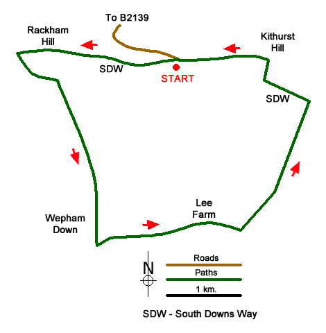
This South Downs walk in West Sussex starts from the Kithurst Hill carpark (grid ref. TQ070125) which can be reached by a lane off the B2139 a few miles southwest of Storrington. The route includes generally easy walking across the downs. The walk starts by ascending Rackham Hill and continues south in a loop before heading north to join the South Downs Way to return to the start via Kithurst Hill.
After parking return to the car park entrance and turn right and right again to Join the South Downs Way heading west with the escarpment on your right. Continue along the well-trodden path taking the right-hand fork at the first junction to reach the trig point on Rackham Hill (grid ref. TQ053126). A brief pause to enjoy the view north before continuing along the South Downs Way for 300 metres to path junction (grid ref. TQ050125) where you turn left to follow a clear path with a small wood on your right. The track curves gently left to reach a junction about 300 metres beyond the end of the trees (grid ref. TQ056122).
Go straight across the wider track and take the continuing path which runs between trees. Ignore all paths/tracks to the right and left. After two kilometres of mostly downhill walking you pass a stand of trees on your left before reaching Weopham Down and a complex junction of tracks (grid ref. TQ060101). Turn left here and follow the track which passes to the north of some trees and continues in an easterly direction to reach Lee Farm (grid ref. TQ076104).
Keep straight ahead through the farm. Ignore the bridleway on the left and continue past some houses on your left to reach some barns on the left side of the track. Walk past the barns and take the signed bridleway on the left (grid ref. TQ078103). Follow this clear track for two kilometres to reach the South Downs Way at the Chantry Post (grid ref. TQ087119).
Turn left onto the South Downs Way. After 700 metres, turn right onto a path leading north to the OS trig point on Kithurst Hill. Turn left past the trig column and continue along Chantry Way back to the start.
Messaging & Social Media
Message Walking Britain and follow the latest news.

Mountain Weather
Stay safe on the mountains with detailed weather forecasts - for iOS devices or for Android devices.