Rackham Hill & Kithurst Hill Circular
South Downs Walk
Nat Park - South Downs
County/Area - West Sussex
Author - Lou Johnson
Length - 6.7 miles / 10.9 km Ascent - 600 feet / 182 metres
Time - 4 hours 0 minutes Grade - easy/mod
Walk Route Description
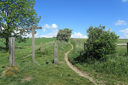
Click image to see photo description.
This South Downs walk in West Sussex starts from the Kithurst Hill carpark (grid ref. TQ070125) which can be reached by a lane off the B2139 a few miles southwest of Storrington. The route includes generally easy walking across the downs. The walk starts by ascending Rackham Hill and continues south in a loop before heading north to join the South Downs Way to return to the start via Kithurst Hill.
After parking return to the car park entrance and turn right and right again to Join the South Downs Way heading west with the escarpment on your right. Continue along the well-trodden path taking the right-hand fork at the first junction to reach the trig point on Rackham Hill (grid ref. TQ053126). A brief pause to enjoy the view north before continuing along the South Downs Way for 300 metres to path junction (grid ref. TQ050125) where you turn left to follow a clear path with a small wood on your right. The track curves gently left to reach a junction about 300 metres beyond the end of the trees (grid ref. TQ056122).
Go straight across the wider track and take the continuing path which runs between trees. Ignore all paths/tracks to the right and left. After two kilometres of mostly downhill walking you pass a stand of trees on your left before reaching Weopham Down and a complex junction of tracks (grid ref. TQ060101). Turn left here and follow the track which passes to the north of some trees and continues in an easterly direction to reach Lee Farm (grid ref. TQ076104).
Keep straight ahead through the farm. Ignore the bridleway on the left and continue past some houses on your left to reach some barns on the left side of the track. Walk past the barns and take the signed bridleway on the left (grid ref. TQ078103). Follow this clear track for two kilometres to reach the South Downs Way at the Chantry Post (grid ref. TQ087119).
Turn left onto the South Downs Way. After 700 metres, turn right onto a path leading north to the OS trig point on Kithurst Hill. Turn left past the trig column and continue along Chantry Way back to the start.
Maps 

| Ordnance Survey Explorer OL10 | Sheet Map | 1:25k | BUY |
| Anquet OS Explorer OL10 | Digital Map | 1:25k | BUY |
| Ordnance Survey Digital Map Subscription | |||
| Latest Ordnance Survey Discounts | |||
Other walks nearby
| Walk 1917 | Rackham Hill from Amberley | easy/mod | 6.5 miles |
| Walk 1615 | Amberley & East Dean Circular | mod/hard | 21.0 miles |
| Walk 1466 | Amberley and Arundel Circular | moderate | 13.0 miles |
| Walk 1628 | Bignor Hill and The Denture from Amberley | moderate | 8.7 miles |
| Walk 1629 | The River Arun & South Stoke | easy | 4.6 miles |
| Walk 3305 | Amberley Mount and Wepham Down | easy/mod | 8.0 miles |
| Walk 3310 | Washington to Littleton Farm by the South Downs Way | moderate | 13.0 miles |
| Walk 3078 | Cissbury Ring & Chanctonbury Ring from Washington | easy/mod | 8.3 miles |
| Walk 3080 | Arundel Park and the River Arun | easy/mod | 7.2 miles |
| Walk 2835 | Arundel to Amberley | easy | 6.2 miles |
Recommended Books & eBooks
The South Downs Way
 Guidebook to walking the South Downs Way National Trail, a 100 mile (160km) route between Winchester and Eastbourne through the South Downs National Park, described in both directions over 12 stages. Easy walking on ancient and historical tracks, taking in wooded areas, delightful river valleys and pretty villages. With 1:25K OS map booklet.
More information
Walks in the South Downs National Park
 Guidebook with 40 circular walks throughout the South Downs National Park, exploring the beautiful chalk hills between Eastbourne and Winchester. The walks range from under 5 miles to 11 miles, including Beachy Head and the Seven Sisters, Ditchling Beacon and hundreds of prehistoric sites. Accessible all year, but wild flowers best in spring.
More information
