Walk 3484 - printer friendly version
The Fair Mile & Unhill Bottom, near Streatley Walk
Author - Lou Johnson
Length - 7.8 miles / 12.7 km
Ascent - 700 feet / 212 metres
Grade - easy/mod
Start - OS grid reference SU567813
Lat 51.5277730 + Long -1.1840611
Postcode RG8 9QG (approx. location only)
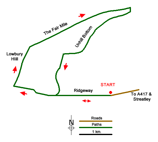
This Berkshire walk explores the downs to the north-west of Streatley. The route is easy to follow initially using a section of the Ridgeway National Trail. The route then continues across the eastern flank of Lowbury Hill before following the grassy Fair Mile in easterly direction. The walk then starts its return walking through the beautiful dry valley of Unhill Bottom back to the start. The walk offers many fine views typical of the Berkshire Downs.
To reach the start drive north on the A329 from the centre of Streatley. Fork left onto the A417 signed to Wantage. Continue for 400 metres and at the next junction fork left into Rectory Road signed to Goring and Streatley Golf Club. Continue for two kilometres to the end of the lane. A small car park can be found to the right of the post box (grid ref. SU567813). After parking exit the rear of the car park and follow the Ridgeway National Trail for three kilometres of easy walking to a junction of tracks with a three-way fingerpost on your left (grid ref. SU540815).
A few metres past the fingerpost take the fingerpost take the right-hand track. Continue ahead on the rising track (with hedge left) across the flank of Lowbury Hill. Continue over the brow of the hill and after 400 metres turn right along the Fair Mile. Continue for three kilometres descending the track down the centre of a broad grassy strip. On the way you pass the entrance to Ashdown Motorcross Track on your left after which you pass through an area with small trees and shrubs. The view to the right opens up and the next objective is a marker post on the right. Turn right here, cross the stile and follow the hedge downhill. Where the hedge bends to the left, continue ahead down to a track.
Turn right along the track. Where the track turns left continue straight ahead onto a well-defined path that climbs up the middle of the dry valley of Unhill Bottom. The path is maintained when the fields are in crop. Continue on the clear rising path to reach a track (grid ref. SU554824). Turn left and continue uphill to reach the top of the hill and enter woodland. Continue through the trees and descend to the Ridgeway. Turn sharp left and return downhill back to the start.
Messaging & Social Media
Message Walking Britain and follow the latest news.

Mountain Weather
Stay safe on the mountains with detailed weather forecasts - for iOS devices or for Android devices.