Walk 3489 - printer friendly version
Scale Bridge & Low Wood from Greendale Walk
Author - Lou Johnson
Length - 5.2 miles / 8.5 km
Ascent - 370 feet / 112 metres
Grade - easy
Start - OS grid reference NY144055
Lat 54.4376760 + Long -3.3212720
Postcode CA20 1EU (approx. location only)
This Lake District walk explores the area between the southern end of Wast Water and the village of Nether Wasdale. The undulating route offers some wonderful scenery including the high Lakeland Fells above Wasdale Head and the Wastwater Screes. The walk crosses variety of terrain and includes a pleasant woodland walk by the shores of Wast Water.
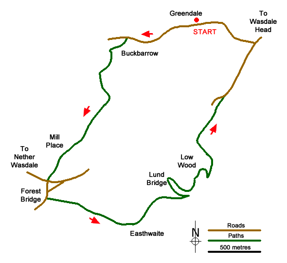
The start is a small area of grassy verge just east of Greendale on the north side of the road (Grid ref. NY144055) at the foot of the path from Greendale Tarn. After parking, turn right along the road past the cottages on your right. Continue past another solitary cottage and the crags of Buckbarrow, both on your right. Continue along the road for another 700 metres and turn left down a track (grid ref. NY137055) that leads down to Buckbarrow. Pass the house on your left and bear right to join a walled track. The track enters a field. Keep the wall on your left and follow the path around the field edge to the far left-hand-corner.
Turn left here through a gate (grid ref. NY134051) and follow the path with the wall on your right. At the end of this field go through another gate into a smaller field. Again, keep the wall to your right. Reaching the corner of this smaller field, turn left and continue with the wall on you right. Continue following the clear path as it swings to the right. Continue to cross Scale Bridge. Follow the path south-west passing Mill Place on the right from where you follow a clearer track to reach a road to the east of Nether Wasdale (grid ref. NY129039).
Turn right and almost immediately left to follow a lane through trees. Reaching a road junction continue straight ahead signed to Holmrook. Cross Forest Bridge and turn left onto signed footpath to Wastwater. Follow the track to Easthwaite (grid ref. NY137034). Continue through the farmyard and follow a clear track to reach the River Irt. Turn left and follow the river upstream to Lund Bridge. Cross the bridge and turn right following the path with the river on your right. Stay on this path enjoying the views across Wast Water. Continue past Wasdale Hall Youth Hostel on your left to reach a road (grid ref. NY148048). Turn right up the road with Wast Water on your right. Follow the road for 700 metres to a road junction (grid ref. NY151054). Turn left, signed for Gosforth, and continue along the road back to the start.

Mountain Weather
Stay safe on the mountains with detailed weather forecasts - for iOS devices or for Android devices.

