Walk 3504 - printer friendly version
Highley to Bewdley along the River Severn Walk
Author - Lou Johnson
Length - 7.0 miles / 11.4 km
Ascent - 50 feet / 15 metres
Grade - easy/mod
Start - OS grid reference SO749830
Lat 52.444382 + Long -2.3707047
Postcode WV16 6NU (approx. location only)
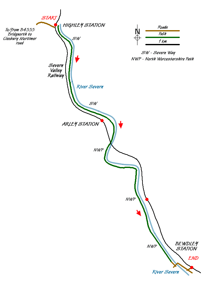
This linear walk follows the River Severn south from Highley to the bustling town of Bewdley. The return uses the Severn Valley Railway with its beautifully preserved stations and steam hauled trains. The route uses a section of the Severn Way and also a part of the North Worcestershire Path.
The start is Highley Station where limited parking is available (grid ref. SO749830). An alternative place to park is the car park at the Severn Valley Country Park (grid ref. SO745829). From here it is a short walk downhill to the railway station. Before setting out on the walk do check the train service from Bewdley back to Highley (SVR website). In winter and other off-peak periods there is either a limited service or no trains at all so alternative arrangements may need to be made for the return journey.
From the station car park, cross the railway tracks and go through the gate at the end of the platform. Following the footpath sign, drop down to the riverside path and turn right. The River Severn is quite wide here and apart from periods after heavy rain is quite docile and gently flowing. Turn downstream and with the river on your left follow the Severn Way. Apart from a few sections where the path is not too obvious, the route is never really in doubt as you follow the river. There are a few places along the path from where you get a good view of the trains and these always look magnificent with a steam loco in charge.
The first sign of significant habitation is the village of Upper Arley on the opposite bank of the river. Today there is a rather ugly footbridge across the river which is met at grid ref. SO765800. You can curtail the walk here by turning right up the lane to Arley Station from where you can catch a train back to the start.
The Severn Way crosses the footbridge to the other bank using the footbridge. Remaining on the west bank we now join the North Worcestershire Path and continue downstream. Quite soon after leaving Arley you pass under the magnificent Victoria Bridge that carries the SVR across the River Severn. Shortly after the path enters Seckley Wood which offers pleasant shady walking for a while and the path turns east. Leaving the woodland the path reaches Folly Point where the river resumes its southerly course.
You pass under another bridge carrying water across the Severn. Further downstream the piers of a former railway bridge (grid ref. SO779764) that carried the line towards Cleobury Mortimer stand as reminders of the "Railway Age". Soon there are extensive signs of habitation as you enter the outskirts of Bewdley. The path reaches the riverside embankment and is flanked by houses, pubs and shops on your right. You might wish to explore the town which lies to your right. However the route continues across the road bridge over the Severn from where you follow the signs the SVR station. All that remains is a pleasant trip by train along the river, perhaps offering an opportunity to spot the path you have just walked.
Messaging & Social Media
Message Walking Britain and follow the latest news.

Mountain Weather
Stay safe on the mountains with detailed weather forecasts - for iOS devices or for Android devices.