Walk 3527 - printer friendly version
Dovedale and Manifold Valley from Ilam Walk
Author - Lou Johnson
Length - 7.5 miles / 12.2 km
Ascent - 1620 feet / 491 metres
Grade - moderate
Start - OS grid reference SK135508
Lat 53.054288 + Long -1.800043
Postcode DE6 2AZ (approx. location only)
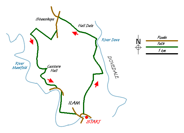
Visiting two contrasting valleys this Peak District walk avoids the busiest part of Dovedale by taking a high level route above the valley. An easy cross country route then takes you to a dramatic view of the Manifold Valley.
The start is near the centre of Ilam village (grid ref SK135508) where on street parking is usually available. If not there is pay and display parking alongside Ilam Hall. After parking walk east along the road towards Thorpe. Just past the last building go over the stile on the left. Ignore the main path to Dovedale, instead walk north on a less obvious path that climbs across the western flank of Bunster Hill. The right of way crosses the field on your left but there is no need to follow this. Just continue walking uphill with the field boundary on your left. Ignore the path leading to Ilammoor Lane and continue alongside the field boundary to reach a stile (Grid ref. SK139520). Cross the stile and field to enter a walled lane with trees.
Turn right to Air Cottage as you reach Ilamtops Farm and continue to follow the waymarked route around the back of Air Cottage. The onward path follows the western rim of Dovedale and you get some good views into the dale and across to the other side. The route is well signed and eventually you begin to descend into Dovedale. The path zigzags down to reach the banks of the River Dove below Ilam Rock. Turn left and follow the clear path alongside the river.
Turn left into Hall Dale. Walk up the dale ignoring any paths going left. You reach a walled lane at Stanshope (Grid ref SK128542). Turn left up to the road. Go left (south) down Ilammoor Lane. After approximately 400 metres take the signed path on your right. Cross two fields to reach a path junction. Turn right and with the field boundary on your right continue across 5 fields. Turn left at the footpath sign on the far side of the fifth field. Follow this path to the rim of the Manifold Valley.
Turn left and continue along the right of way to reach a track at the rear of Castern Hall (Grid ref SK123524). Bear right onto the track and continue round the Hall and follow the access road downhill. The access road joins a lane. Continue ahead as far as the River Lodge cottage on the right. Just after the cottage turn right down the footpath. This follows the River Manifold (often almost dry) around the grounds of Ilam Hall. You reach a point where the river appears from its life underground. Go left here and walk towards the lawns of Ilam Hall. Go right to pass the church (keep it on your right) and then continue down the path to the centre of Ilam.
Messaging & Social Media
Message Walking Britain and follow the latest news.

Mountain Weather
Stay safe on the mountains with detailed weather forecasts - for iOS devices or for Android devices.