Walk 3528 - printer friendly version
Fountains Abbey & Markenfield Hall Walk
Author - Lou Johnson
Length - 8.7 miles / 14.1 km
Ascent - 750 feet / 227 metres
Grade - moderate
Start - OS grid reference SE272687
Lat 54.1134600 + Long -1.5854201
Postcode HG4 3DZ (approx. location only)
Fountains Abbey provides the focus for this North Yorkshire Walk which is full of variety and historic interest. If you wish to visit the Abbey ruins and Water Gardens, then an admission fee is payable (free to NT members). The route includes a variety of terrain from dales to open farmland. Along the way you pass Markenfield Hall and cross part of Studley Royal Park.
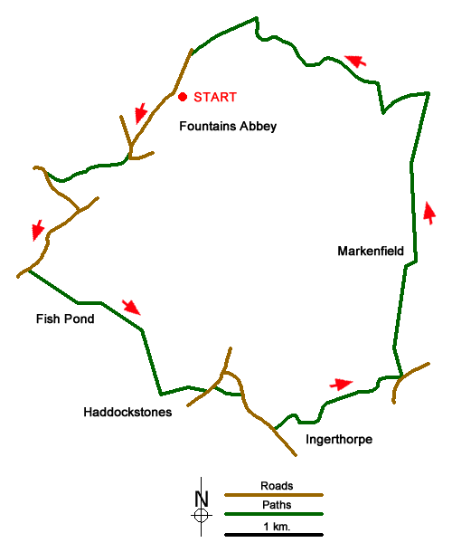
The start is the pay and display Car Parks at Fountains Abbey - either car park A or car park B (grid ref. SE272687). After parking walk to the roundabout at the entrance to these car parks and bear left along the access road following the segregated bridleway which is part of the Ripon Rowell Walk. Continue to Aldfield Road (grid ref. SE268863). Turn left and follow the road downhill to take the stile/gate on the right along a clear track in the Skell Valley. Continue along the track to reach a stone footbridge. Cross the bridge and take the uphill path through trees to reach a lane (grid ref. SE260681).
Turn left and continue to a T-junction. Turn right and continue through woodland and after 800 metres take the first bridleway on the left (grid ref. SE259671). The path descends to cross a causeway across a lake (Fish Pond). The bridleway passes through Foal Cote farmyard to reach the farm's access road. Turn left and shortly after turn right along a track (with field boundary on the left). Continue along the field and into the next still following the clear track. Where the track bends to the left (grid ref. SE271662), you continue straight ahead for 250 metres to the end of the field. Turn left here and follow the path (field boundary on your left) to join a quarry track which leads to Watergate Road (grid ref. SE276661).
Cross the road, turn left and take the path on your left across a field. The path follows left hand side of the field before turning left along a stand of trees (which will be on your right) to reach Westerns Lane (grid ref. SE279660). Turn right and after 450 metres turn left along a driveway. Note there is no waymark but there is a right of way). Continue towards Ingerthorpe Grange bearing left down to a gate into the Yorkshire Riding Centre. Again, there are no waymarks but continue straight ahead along a track through parkland skirting Ingerthorpe Hall on your left. The track curves to the left and then to the right to reach a road (grid ref. SE294661).
Turn sharp left along a track. You are now on the Ripon Rowell walk again, which is followed back to the start. After 250 metres take the path on the right (grid ref. SE292664). The path then crosses fields to reach Markenfield Hall. Go through a gate by some farm buildings and turn right. At the end of the buildings turn left and walk north alongside a wall and into a field. The path goes straight across the field to the right-hand corner and a bridge. Cross the bridge and bear left. Maintain your direction (roughly northerly) to join the access drive to Bland Close Farm on your right. Continue ahead at the first junction of tracks. Just before Whitcliffe Hall (on your right), turn left onto a path with the fence to your left.
After 500 metres the path drops down to a cross track (grid ref. SE292686). Turn right and continue to a bridge over the River Skell. After crossing the river turn left and follow the clear path up the dale to enter Studley Royal Park by a gate. Continue over several bridges to reach the weir at the outfall from The Lake. Cross the weir using the bridge and continue straight ahead along the clear path as far as a wide track which is reached after 300 metres from the weir. Turn left along the wide track. Walk past the Cloister House and St Mary's Church (both on your right) you exit the parkland near an obelisk. Turn left and follow the path alongside the road back to the start.
Messaging & Social Media
Message Walking Britain and follow the latest news.

Mountain Weather
Stay safe on the mountains with detailed weather forecasts - for iOS devices or for Android devices.