Walk 3532 - printer friendly version
Runswick Bay to Staithes Walk
Author - Lou Johnson
Length - 3.8 miles / 6.2 km
Ascent - 735 feet / 223 metres
Grade - easy
Start - OS grid reference NZ807161
Lat 54.5337540 + Long -0.75437945
Postcode TS13 5JF (approx. location only)
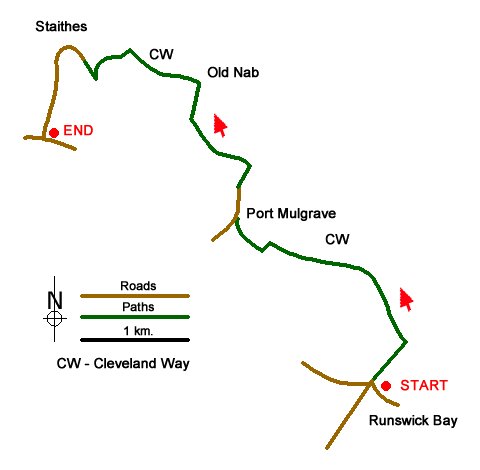
This North York Moors walk follows the Cleveland Way along the cost from Runswick Bay to Staithes. It is a linear walk and uses the regular X4 bus service to return to the start. There is generally enough parking at the cliff top car park at Runswick Bay (grid ref. NZ807161). We chose to park at Runswick Bay where parking is generally easier than in Staithes. As an alternative park in Staithes (grid ref. NZ780185).
Exit the car park on the left-hand side of the toilets and turn left along the road. Reaching the road junction, turn right following the Cleveland Way fingerpost. The route is easy to follow, and this National Trail is well signed throughout the walk. After 500 metres the path reaches the coast. Turn left and with the North Sea on your right continue to Port Mulgrave. Once a busy port for the export of ironstone very little evidence remains of its past. However small boats use the beach and the remains of the harbour can still be seen.
Reaching a road (grid ref. NZ795174), bear right and follow the cliff top. Reaching the end of the road the Cleveland Way is signed and you continue along the path with excellent along the coast in both directions. After half a mile your reach a junction of paths (grid ref. NZ792183). Turn right here, still on the Cleveland Way, and descend to Old Nab which is a prominent rock. Bear left along the coast path and continue for a further half a mile to be rewarded with a grandstand view down to the village of Staithes with its busy harbour.
The path leads to a farm (grid ref. NZ784186) where you turn sharp right to descend steeply down into the village. Staithes has many shops, pubs and cafés and is the only place on the walk where refreshments are available. The village is a maze of narrow lanes and alleys and it is worth spending time exploring these. To continue follow the 'Main Street' uphill. You pass the car park mentioned as an alternative starting point on your left. You reach the main road after a further 400 metres. Turn left and the bust stop for the X4 is a short way along this road. For most of the week the service is every thirty minutes and the bus will return you to the junction in Runswick Bay a few yards from where you parked.
Messaging & Social Media
Message Walking Britain and follow the latest news.

Mountain Weather
Stay safe on the mountains with detailed weather forecasts - for iOS devices or for Android devices.