Walk 3562 - printer friendly version
The Weaver Hills from Wootton Walk
Author - Lou Johnson
Length - 3.2 miles / 5.2 km
Ascent - 500 feet / 152 metres
Grade - easy
Start - OS grid reference SK103452
Lat 53.0040200 + Long -1.8479608
Postcode DE6 2GW (approx. location only)
This short Staffordshire walk takes to the summit of the Weaver Hills which lie in the north of the County some five miles east of Ashbourne just across the border in Derbyshire. The Weaver Hills are by many considered to be the southernmost outpost of the Pennine Hills which stretch north to the Scottish border. The route is easy to follow and offers some good views east across the Dove Valley as well as north into the Peak District National Park.
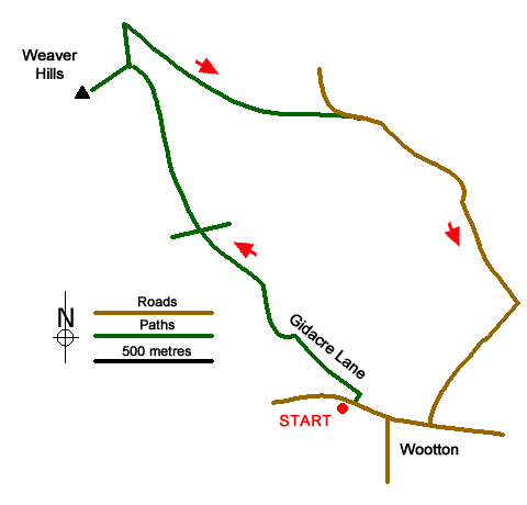
The start is the small carpark west of Wootton village (grid ref. SK103452) on the south side of the road to Ramshorn. Note the car park is a grassy area on the left just past the entrance to Wootton Crick Club on the right. After parking turn right down the road to wards the village. Turn left along Gidacre Lane (the track leading to the cricket club) and continue to where the track turns sharp left to the clubhouse. At this point cross the stile and walk towards the top left-hand corner of the field crossing a track along the way. Pass through a gate and follow the arrow across the next field heading half left to reach a stile by a gate in the wall.
Continue ahead to reach a green sign and then head towards Wardlow. The path rises with the wall to your left to reach another gate. Continue straight ahead bearing left at a footpath sign. Stay with the wall and cross stile to follow a path to the summit of the Weaver Hills, which is marked with a trig point.
After enjoying the view return to the stile to the footpath sign passed earlier. Go half left to cross the stile in a wall and then continue bearing right to a green sign (grid ref. SK096466). Go right here and with the wall on your left continue for a kilometre to reach a lane. Bear right down the lane. An easy walk of just over 1.6 kilometres leads you back to Wootton. Turn right at the first road junction and continue ahead through the village to reach the road where you started. The car park is a short way along on the left-hand side.
Editor's Note - it has been reported that electric fences have been installed on the outward section of the route. However, the landowner has left suitable places to cross and these fences will present no difficulties for walkers following this route.
Messaging & Social Media
Message Walking Britain and follow the latest news.

Mountain Weather
Stay safe on the mountains with detailed weather forecasts - for iOS devices or for Android devices.