Walk 3564 - printer friendly version
Groesfford and M & B Canal from Brecon Walk
Author - Lou Johnson
Length - 6.2 miles / 10.1 km
Ascent - 500 feet / 152 metres
Grade - easy/mod
Start - OS grid reference SO042286
Lat 51.9476170 + Long -3.3952474
Postcode LD3 9AN (approx. location only)
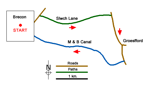
A Brecon Beacons National Park walk starting beside the River Usk explores the countryside and the Monmouthshire and Brecon canal to the east of the town. Brecon has several car parks in the centre but the long-stay car park by the Watergate Bridge (grid ref. SO042286) is the most convenient for this walk. After parking turn right and cross Watergate Bridge. Go straight across the junction into Ship Street. Reaching the High Street bear right and continue to pass St Mary’s church on your right. Continue ahead into Bulwark Street. After a short distance turn left into Free Street (B4602).
Continue along Free Street past terraced houses. At the next junction (with traffic lights) go straight across. Continue up the B4602, walk past the hospital and just after the ambulance station (both on your right) take the path on your right between trees. This is Slwch Lane which is followed for 2.4 kilometres past Slwch Farm, through the underpass beneath the A470 to reach a lane (grid ref. SO073289).
Turn right and follow this lane south to reach the village of Groesffordd (grid ref. SO076279). Continue ahead through the village. At the next junction go straight ahead, continue under the A40 to reach a bridge over the Monmouthshire and Brecon Canal (grid ref. SO077273). Just over the canal, turn right through the gates and follow the towpath (with the canal on your right). Stay on the towing path all the way back into Brecon, a distance of 3.5 kilometres. Reaching the end of the canal, go straight ahead onto Canal Road. Just after Canal Road bends right, take the tarmac lane on the left (signed no through road). This lane leads down to the path alongside the River Usk. At the first bridge, take the steps on the left up to the road. Turn right. Take the next road left (Watergate) and the car park is a short way along this road on the left.
You can easily extend this walk by combining it with Walk 3210 to make a figure of eight route visiting the hill fort of Pen-y-Crug to the west of Brecon to enjoy dome fine views across the Usk Valley and the surrounding hills of the National Park.
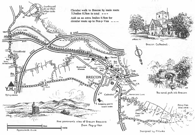
This walk was originally conceived by Martyn Hanks for Youth Hostellers staying at the Ty'n-y-Caeau Youth Hostel near Brecon. The route followed a figure of eight and for the convenience of all walkers the route has been split in two with each loop being a separate walk based from the centre of Brecon. The routes were drawn in a 'Wainwright' style and provided annotated maps offering additional information for walkers. Prepared before the days of GPS they were an invaluable resource and Walking Britain is happy to ensure that these walks remain in the public domain.
Messaging & Social Media
Message Walking Britain and follow the latest news.

Mountain Weather
Stay safe on the mountains with detailed weather forecasts - for iOS devices or for Android devices.