Walk 3565 - printer friendly version
The Hergest Ridge from Gladestry Walk
Author - Lou Johnson
Length - 6.1 miles / 9.9 km
Ascent - 920 feet / 279 metres
Grade - easy/mod
Start - OS grid reference SO233552
Lat 52.1896860 + Long -3.1234034
Postcode HR5 3NR (approx. location only)
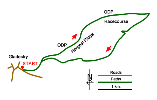
This Powys walk starts from the village of Gladestry and traverses the Hergest Ridge which is a whaleback of a hill lying across the Wales and England border a few miles west of Kington in Herefordshire. The hill is traversed by the Offa's Dyke Path and during the walk you visit the racecourse which flourished in Victorian Times high above the surrounding countryside.
The start is the village of Gladestry. Parking is available in a lay-by on the B4594 just north of the village school (grid ref. SO233552). After parking walk down past the school (on your right) to a road junction. Turn left signed to Huntington. Follow this road as it bends right and continue to reach the next road junction (grid ref. SO234551). Bear left here up the no-through road, which climbs steadily, and continue up to gate which provides access to the hill.
Walk straight ahead following the signed Offa's Dyke path. This is the main path across the hill and navigation is straightforward. After just over two kilometres you pass the OS trig point on your right, which can be visited with very little extra effort. Away to your left you have outstanding views which reach as far as the Brecon Beacons National Park while to your right the views extend to the Shropshire Hills.
Stay on the Offa's Dyke Path, which starts to descend for a further kilometre. Ahead is a grand view down to Kington. You reach a fence with a field beyond (grid ref. SO273568). Turn sharp right here and, with the fence of your left, continue for about 600 metres to reach a path junction with Bage Farm below on your left. Go straight across the path junction and follow the path as it curves right and descends into a valley. Follow the path as it then bears left and climbs out of the valley. After a short ascent the path initially follows a fence (on your left) before descending across the hillside to pass to the right of another fence.
Where the fence bears left, continue ahead to reach a path junction with a marker post. Go straight across and continue along the path across the hillside to reach a fence (grid ref. SO254553). The path soon bears right into a shallow valley (Rabber Dingle). Continue on the path as it trends to the left. The onward path is easy to follow and generally follows a fence (on your left) and soon re-joins the Offa's Dyke Path which you used earlier in the walk. Retrace you steps down to the gate and follow the lanes back into Gladestry where refreshments are available at the Royal Oak pub.
Messaging & Social Media
Message Walking Britain and follow the latest news.

Mountain Weather
Stay safe on the mountains with detailed weather forecasts - for iOS devices or for Android devices.