Walk 3571 - printer friendly version
Holdenby from East Haddon Walk
Author - Lou Johnson
Length - 5.9 miles / 9.6 km
Ascent - 400 feet / 121 metres
Grade - easy
Start - OS grid reference SP668681
Lat 52.3069620 + Long -1.0216794
Postcode NN6 8BU (approx. location only)
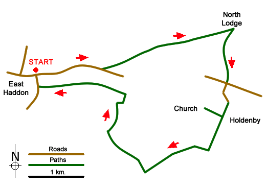
This Northamptonshire walk explores the rolling countryside to the east of the village of East Haddon. The route includes glimpses of the Elizabethan Palace of Holdenby House, visits an interesting 14th century church and offers some lovely views across rural landscapes. The start is the village of East Haddon where limited on street parking is available in Church Lane (grid ref. SP668681) which leads south from the Parish Church on Main Street.
After parking walk towards the church and turn right onto Main Street, which becomes Holdenby Road. Reaching open countryside continue for a further 300 metres pass the speed limit sign using the grass verge. Turn left onto a track by an electricity pole near trees. Almost immediately go right onto a signed public footpath. Go half left across the first field, straight across the next field and then half left across the next to pick up a farm track. Follow this track for 1.4 kilometres to pass Holdenby North Lodge Farm, which is on your left. Continue towards a stile on a lane (grid ref. SP696688). Do not cross the stile but turn sharp right and follow the Macmillan Way in a southerly direction.
The path crosses two fields and heads to the right-hand side of Pinfold Spinney (with another spinney on your left). Maintain direction across two fields to join a lane (grid ref. SP695680). Cross the road and take the lane opposite into Holdenby. This well maintained and beautiful village is a perfect place for a break. The lane bends to the left across the village green. Turn right at a brown sign to the Historic Church (grid ref. SP695678) and follow the track for 300 metres. Turn right and visit 14th century All Saint's church.
Retrace you steps back to the track and turn right still following the Macmillan Way. Pass a small area of woodland on your left and continue for 200 metres. Follow the track as it turns right. The track soon bends half left and then continues to reach a cross track at the end of a row of trees. Go straight across and continue for 500 metres to reach a hedge. Turn right off the track in front of the hedge (grid ref. SP683667) and follow the path across two fields (with hedge on your left). Enter the next field and continue now with the hedge on your right.
Just after the end of this field bear right through a gap and follow a track with the hedge on your left. You soon pass the isolated barn of Rowell Leyes on your left. A hedge comes in from the right. Just after this turn right and follow the field edge (hedge on right) to the end of the field. Turn left and continue past a tree to the corner of the field. Turn left here and follow the path (hedge on your right) and maintain direction across several fields to reach a sports pavilion. Walk past the pavilion to the end of the car park and pick up the footpath on the right. This leads to Church Lane. Turn right and you soon arrive back at the start.
Messaging & Social Media
Message Walking Britain and follow the latest news.

Mountain Weather
Stay safe on the mountains with detailed weather forecasts - for iOS devices or for Android devices.