Walk 3583 - printer friendly version
Brockenhurst, Black Knowl & Ober Water Walk
Author - Dave Ford
Length - 5.0 miles / 8.1 km
Ascent - 150 feet / 45 metres
Grade - easy
Start - OS grid reference SU299028
Lat 50.8239740 + Long -1.5768734
Postcode SO42 7TE (approx. location only)
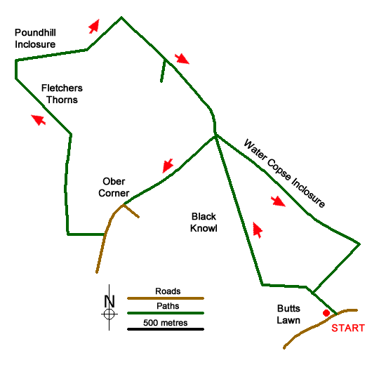
358301 This is another New Forest walk with my Whippet. This walk is a 5 mile circular route to the West of Brockenhurst. Leaving my car at the Balmer Lawn Car Park (where I get to see a couple of "free range" Pigs), I start the walk at Butts Lawn before passing some allotments and head across the open space of Black Knowl. I explore the remains of a 19th Century Hydraulic Ram System at Bolderford Bridge before continuing my walk along the side of Ober Woods to Ober Corner. The route then takes me over Ober Heath, through Fletchers Thorns (where I see some Deer), past Poundhill Inclosure and on to Queen's Meadow. I then take a quick detour to explore some 17th Century clay pits before crossing Lymington River and heading back to the original start point.
Messaging & Social Media
Message Walking Britain and follow the latest news.

Mountain Weather
Stay safe on the mountains with detailed weather forecasts - for iOS devices or for Android devices.