Walk 3589 - printer friendly version
Padstow from Little Petherick Walk
Author - Lou Johnson
Length - 5.0 miles / 8.1 km
Ascent - 500 feet / 152 metres
Grade - easy
Start - OS grid reference SW918721
Lat 50.5115790 + Long -4.9378930
Postcode PL27 7QT (approx. location only)
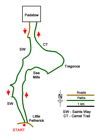
This North Cornwall walk starts from Little Petherick and follows the shores of Little Petherick Creek north to the River Camel. The route then follows The Camel Trail into the bustling town of Padstow where there is a wide choice of refreshments and eating opportunities. After exploring the town and its bustling harbour the walk returns to Little Petherick by following the Saints' Way back to start again following a path alongside Little Petherick Creek.
The start is the small car park adjacent to the village hall in Little Petherick (grid ref. SW918721). After parking return to the road and turn left. Cross the bridge and then turn left again onto a signed public footpath. The path follows a track which leads to a sign and stile. The path then follows the shores of Little Petherick Creek to cross a footbridge and then continues to eventually reach the end of a lane at Sea Mills (grid ref. SW920736).
Continue beside the creek and then turn sharp right along a narrow, signed path. This leads across fields to another lane at Benuick. Turn left and head towards the shore of the creek and then right along the path. Cross a footbridge and climb gently to a track. Turn left and then immediately right to continue along the path to reach a lane in Tregonce. Turn left and follow the lane to reach the Camel Trail which follows a disused railway. Turn left along the trail (which is shared with cyclists) and continue to the end of the trail in Padstow. Continue ahead to the harbour and car parks.
You can now explore Padstow and perhaps have lunch. To continue the walk, start from the National Lobster Hatchery beside the harbour. With your back to the hatchery walk straight ahead with the coach park on your immediate right. You are now on Station Road. Follow Station Road as it bends to the right and continue past The Metropole Hotel on your right. At the next junction turn left along Dennis Road. Follow this road south continuing into Dennis Lane. Where the 'main' road bends right at a crossroads continue straight ahead into Dennis Lane with a 'Slow Down' sign on the left.
Continue along Dennis Lane to reach its end. Continue ahead on the waymarked Saints' Way and follow the track ahead. After 25 metres a short diversion can be enjoyed by taking the path on the left to the top of Dennis Hill. After enjoying the view return to the Saints' Way and turn left. The onward path descends half right to the shores of the creek. A short climb with trees on your left leads eventually to a descent to another small inlet (grid ref. SW915732). The waymarked path then continues with a short ascent through trees to cross a field. At the end of the field the path turns left and then right to join a track which leads back to the start.
Messaging & Social Media
Message Walking Britain and follow the latest news.

Mountain Weather
Stay safe on the mountains with detailed weather forecasts - for iOS devices or for Android devices.