Walk 3591 - printer friendly version
Derrington circular from Stafford Castle Walk
Author - Lou Johnson
Length - 3.6 miles / 5.9 km
Ascent - 150 feet / 45 metres
Grade - easy
Start - OS grid reference SJ903221
Lat 52.7963740 + Long -2.1452988
Postcode ST16 1DJ (approx. location only)
This Stafford walk starts from Stafford Castle and follows a section of The Way for the Millennium. Stafford Castle dates from around 1100 when earthworks were constructed. The site was soon developed with a timber fortress which was later replaced with a 14th century stone-built structure. This was demolished in 1643 during the Civil War. In the 19th century a Gothic Revival style using some of the original stonework. After the Second World War the castle was vacated by the owners and became subject to vandalism with unsafe stonework being removed.
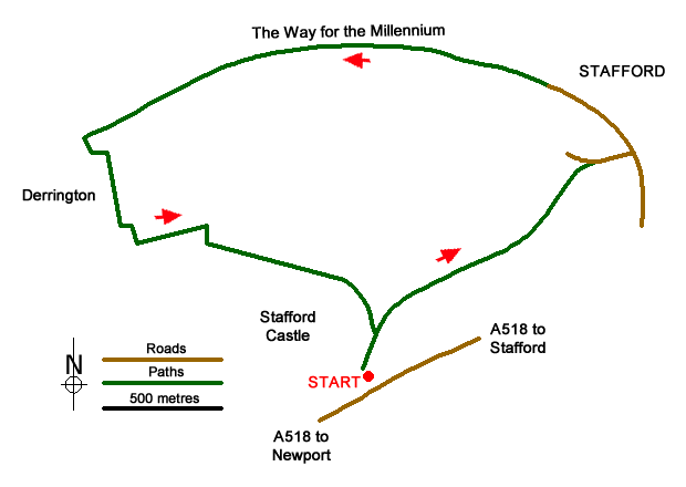
The start of the walk is the Castle car park (grid ref. SJ903221) which is located on the north side of the A518 Stafford to Newport road about two kilometres west of Stafford town centre. After parking exit the car park using the access from the main drive. Using the gate or stile opposite cross a grass field to the far, left hand corner. Bear right to go straight across the next field on a clear path towards some trees. Join the path running between trees with a golf course on your right. Continue straight ahead soon walking across the course with further holes to your left. The path continues to the left of the club house and soon reaches Redgrave Drive (grid ref. SJ913229).
Bear right and continue to a roundabout. Turn left and cross the road to join a cycle track. After 15 metres turn left and follow the track into woodland. The path runs parallel to a stream on your right and Martin Drive on your left. Continue past a roundabout on your left. The path merges with a tarmac track and passes under power lines. Join and bear left along cycle way 55 which was originally the railway from Stafford to Wellington. It is now the Way for the Millennium. Continue along the clear path ignoring side paths. Continue under the M6 Motorway.
500 metres beyond the M6 you reach a bridge over a road (grid ref. SJ892230). Leave the path by following a ramp on the road down to the road. Turn right along the road. Almost immediately turn left into Duddas Wood. After 100 metres turn right at a fingerpost. Continue through a gate and join a narrow, enclosed path with a field to your left.
Where the enclosed path ends, turn left onto a path. Cross a stile and continue through a tunnel under the M6 Motorway. The path bends right and heads up a ramp. At the top of the ramp, bear left and follow the path uphill towards Stafford Castle, which is hidden in trees. The path follows the filed boundary which should be on your left. Where the hedge goes left, continue ahead to reach woodland. Continue along the path with woodland on your immediate left. This path bears right along the edge of woodland and returns you to the start. You may wish to explore the castle and information boards provide historical information and maps.
Messaging & Social Media
Message Walking Britain and follow the latest news.

Mountain Weather
Stay safe on the mountains with detailed weather forecasts - for iOS devices or for Android devices.