Walk 3603 - printer friendly version
Blythburgh from Wenhaston Walk
Author - Lou Johnson
Length - 5.0 miles / 8.1 km
Ascent - 120 feet / 36 metres
Grade - easy
Start - OS grid reference TM423758
Lat 52.3267550 + Long 1.5544622
Postcode IP19 9BF (approx. location only)
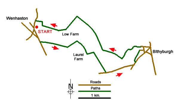
This Suffolk walk starts from the village of Wenhaston and includes one of the finest 15th century church interiors in England at Blythburgh together with a wildlife rich riverside habitat along the banks of the River Blyth. Parking is available at the junction of Byford Lane and Coles Hill (grid ref. TM423758).
After parking walk south on Byford lane and continue straight ahead into The Street. Just after St Peter's Parish Church on the right, turn left into Narrow Way. Continue straight ahead down this residential road which becomes a track after 400 metres. Stay on the track which bends left and then right to reach Laurel Farm (grid ref. TM437752). Continue past the farm, keeping straight ahead at a way marker. Go through the gate following the track which bends to the left. Stay on the track which now bends right. After just over 100 metres leave the track and walk forward into the next field. Aim for the far left-hand corner to reach Wenhaston Lane (grid ref. TM441747).
Turn left along the road and continue to the junction the A12. Turn left and after a few metres take the signed public footpath on the left. This path leads into Church Lane with access to the Holy Trinity Church, Blythburgh on your left.
After visiting the church, bear to the left of the entrance and go down the steps at the back. At first walk right and then go left to climb onto the riverbank. Turn upstream (with the river to your right) and follow the clear path for about 2 kilometres. This section of path takes through some fine reed beds which are notes for their varied flora and fauna. Reaching the first bridge continue straight ahead.
At the second bridge, turn left and follow the path which becomes a track leading to Low Farm after 350 metres. Fork right following the field edge and go through gap at the corner. Continue straight across the next field. Turn right at the end of the field to a fingerpost. Turn left here to reach Byford Lane and continue back to the start which is reached after 150 metres.
Messaging & Social Media
Message Walking Britain and follow the latest news.

Mountain Weather
Stay safe on the mountains with detailed weather forecasts - for iOS devices or for Android devices.