Walk 3607 - printer friendly version
Reservoirs Walk from Tintwistle Walk
Author - Lou Johnson
Length - 5.5 miles / 8.9 km
Ascent - 500 feet / 152 metres
Grade - easy/mod
Start - OS grid reference SK023973
Lat 53.4724280 + Long -1.9668175
Postcode SK13 1LB (approx. location only)
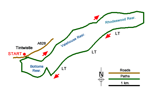
This Peak District walk starts from the village of Tintwistle on the A628 Woodhead Road and follows a series of paths around the three lowest reservoirs of the six that make up the Longendale Chain. At the time of their completion in 1877 the reservoirs formed the largest body of man-made water in the World.
Parking is available along Chapel Brow (grid ref. SK023973) alongside the cemetery wall. After parking, cross the A628 and go down the access road to the Longendale Environmental Centre. Turn right after a gate and then walk left following a sign to the 'Bottoms Path Concessionary' and continue down to the shore of the reservoir. Follow the path along the shoreline (with the reservoir to your right). The path is clear, and you soon pass the dam to Valehouse Reservoir.
The path is easy walking and the route straightforward with a fine view across the water to Bramah Edge. Nearing the dam wall for Rhodehouse Reservoir, take the steeply rising path on your left. This leads up to a road and the top of the dam wall. Turn left, cross the culvert and the take the next path on the right. Follow this path through to the dam wall for Torside Reservoir. Turn right across the top of the dam, joining a short section of the Pennine Way and continue to the far side. Follow the road to the left to turn sharp right onto the Longendale Trail just before the B6105.
You now have just under two miles of easy walking along the Longendale Trail. About halfway along Bottoms Reservoir with a few trees either side of the track turn right of the Trail (grid ref. SK031968) and follow the public footpath that leads half right across to fields to reach the reservoir shoreline. Turn left along the reservoir, with the water to your right, and continue on the shoreline path to reach the dam wall. Cross the dam and turn right up to the environmental centre. Turn left up to the A628 and the start of the walk is opposite.
Messaging & Social Media
Message Walking Britain and follow the latest news.

Mountain Weather
Stay safe on the mountains with detailed weather forecasts - for iOS devices or for Android devices.