Walk 3620 - printer friendly version
Bretton Clough & Abney Moor Walk
Author - Lou Johnson
Length - 6.0 miles / 9.8 km
Ascent - 900 feet / 273 metres
Grade - easy/mod
Start - OS grid reference SK198798
Lat 53.3147670 + Long -1.7042675
Postcode S32 1AH (approx. location only)
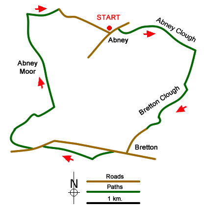
This Peak District walk starts from the village of Abney and explores Abney Clough, Bretton Clough, Hucklow Edge and Abney Moor. The route generally follows well used paths and offers an insight into the pleasant scenery of this area.
The start is Abney where limited on street parking is available (grid ref. SK198798). Please ensure you park with consideration. From the centre of the village walk east and take the track on the right by Millhouse Farm (on your left). The track descends, bears to the left, soon becoming a path and continues down into Abney Clough. The path keeps to the left side of the valley. Just after passing through a gate in a fence, descend towards the river and a signed junction of paths (grid ref. SK211795). Turn right, signed for Bretton and Eyam. Cross a footbridge, pass through a gate and cross another footbridge to reach Stoke Ford and a path junction.
At Stoke Ford take the right fork and climb to another fork (grid ref. SK211794). Take the right fork climbing gently with the valley on your right. Follow the path as it bears left and descends slightly to cross a stream. Once across the stream follow the path southwest. Reaching a path junction (grid ref. SK209788), keep straight ahead walking roughly parallel to a wall on your right and rising ground to your left. The path swings south to cross a stream (grid ref. SK206785).
Cross the stream and turn left through a gate. Follow the path as it climbs through woodland to reach a track at the top (grid ref. SK205784). Turn left and follow the track. Continue past Nether Bretton Farm following a lane which climbs up to a T-junction by the Barrel Inn (grid ref. SK200779). Turn right and at the next road junction take the left fork. Descend slight for 400 metres and take the signed bridleway on the right. Continue for 800 metres to reach a road at Hucklow Edge.
Bear left along the road and at the next junction turn right signed for the Gliding Club and Abney. The lane Go past the entrance to the Gliding Club. Continue along the road with a valley to your right. Bear left where the road forks. Then take the first footpath on the left (grid ref. SK189786). Cross the stile and head north across Abney Moor to reach an enclosed track. Turn right and then after 500 metres turn right again at a junction (grid ref. SK190802). Go through the gate and follow the tarmac lane down into Abney to return to the start.
Messaging & Social Media
Message Walking Britain and follow the latest news.

Mountain Weather
Stay safe on the mountains with detailed weather forecasts - for iOS devices or for Android devices.