Longcot & Uffington Circular
Oxfordshire Walk
County/Area - Oxfordshire
Author - Lou Johnson
Length - 5.2 miles / 8.5 km Ascent - 150 feet / 45 metres
Time - 2 hours 50 minutes Grade - easy
Maps 

| Ordnance Survey Explorer 170 | Sheet Map | 1:25k | BUY |
| Anquet OS Explorer 170 | Digital Map | 1:25k | BUY |
| Ordnance Survey Landranger 163 | Sheet Map | 1:50k | BUY |
| Anquet OS Landranger 163 | Digital Map | 1:50k | BUY |
| Ordnance Survey Landranger 164 | Sheet Map | 1:50k | BUY |
| Anquet OS Landranger 164 | Digital Map | 1:50k | BUY |
Walk Route Description
Click image to see photo description.
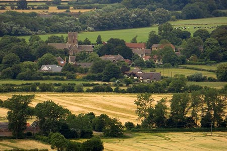
This Oxfordshire walk starts from the village of Longcot in the Vale of the White Horse. The route follows the D'Arcy Dalton Way to Uffington where you pass the former home of Sir John Betjeman and Tom Brown's School Museum before returning to the start.
Limited on street parking can be found on Fernham Road located on the east side of St Mary's the Virgin parish church (grid ref. SU274907). After parking walk south to the T-junction with Farnham Road (B4508). Go straight across the road to the signed footpath with a stile and gate. Continue on the waymarked path across several fields to pass under the railway. The path crosses two more fields to reach a stile and Claypit Lane.
Turn left along the lane. At the first junction go straight ahead signed to Uffington. At the next junction continue ahead to Uffington. Soon after you enter the village of Uffington. At the next T-junction, with a thatched cottage on the right, you can make an optional detour by turning right and follow the road that leads into the village centre to pass Sir John Betjeman's House which is opposite the Fox and Hounds pub. The main route continues left at the T-junction and continues to reach Tom Brown's School Museum.
Take the lane to the left of the Museum, Fernham Road, and continue for about 700 metres to just past Wharf Farm (on your right). Take the footpath on the left by some metal railings. Cross the stile and follow the path on the left-hand side of the field. The path turns right, left and then right following the hedge line. Pass under the railway using the tunnel, cross stile, turn right and then left through a metal gate. The path follows the line of power lines across a field to the left of a barn. Entering the next field, the path heads towards the far hedge. In the next field go half left to another hedge. The path then crosses several fields with the church tower ion Longcot providing a useful landmark. Continue to the road and the start.
Other walks nearby
| Walk 1554 | Wayland's Smithy & Uffington Castle | easy/mod | 5.5 miles |
| Walk 1069 | Badbury Hill, including the Great Barn at Great Coxwell | easy | 6.0 miles |
| Walk 2915 | Uffington Castle, the White Horse and Wayland's Smithy | easy/mod | 6.5 miles |
| Walk 3116 | Uffington White Horse & Wayland's Smithy | easy | 3.3 miles |
| Walk 1061 | Faringdon, Radcot and Littleworth | easy/mod | 8.0 miles |
| Walk 1063 | Faringdon, Buckland & Pusey | easy/mod | 10.5 miles |
| Walk 1064 | Faringdon Folly, Buckland Warren and Hatford | easy/mod | 8.0 miles |
| Walk 1066 | Faringdon, Wicklesham, The Folly & Folly Park | easy | 4.0 miles |
| Walk 1079 | Faringdon, Thrupp and towards Lechlade | easy | 6.5 miles |
| Walk 1068 | Faringdon, Fernham and Little Coxwell | easy | 6.0 miles |
Recommended Books & eBooks
No suggestions for this area.Messaging & Social Media
Message Walking Britain and follow the latest news.

Mountain Weather
Stay safe on the mountains with detailed weather forecasts - for iOS devices or for Android devices.