Walk 3635 - printer friendly version
Barnsley Park Walk
Author - Lou Johnson
Length - 11.0 miles / 17.9 km
Ascent - 700 feet / 212 metres
Grade - moderate
Start - OS grid reference SP115067
Lat 51.7588710 + Long -1.8347851
Postcode GL7 5NN (approx. location only)
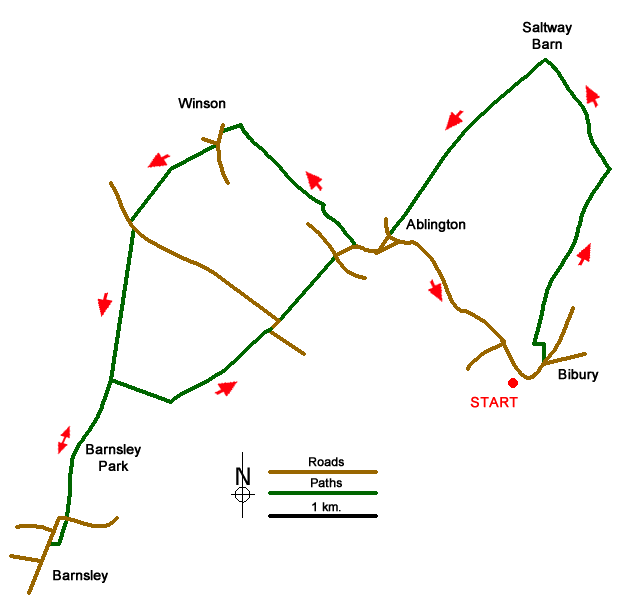
This Cotswolds walk from Bibury is full of interest exploring classic villages with stone-built cottages, open countryside, Barnsley Park with its imposing house and a pub at the halfway point. The route uses paths, bridleways and quiet country lanes with navigation relatively easy. A shorter version of this walk can be found at Walk 3636.
The start is the attractive village of Bibury where parking is available in a lay-by beside the River Coln just north of the small stone footbridge across the river (grid ref. SP115067). After parking cross the road and walk south along the B4425 with the river on your right. Continue past the Post Office and around a left-hand bend. Continue to the end of the pavement, pass a letter box in the wall on your left and take the next left (Packhorse Lane) signed as a no-through road. The track bends left and then right continuing as a grassy track. Follow the bridleway for about a kilometre, passing the rear of Bibury Far on your right and a barn on the left to reach a junction of tracks (grid ref. SP123082).
At the junction, take the left-hand-fork through a gate and follow the bridleway for a kilometre to reach Saltway Barn at a junction of tracks (grid ref. SP118092). Turn left along a bridleway, which is enclosed by hedges for part of the way, for two kilometres to reach a lane in Ablington village (grid ref. SP106077). Turn left along the lane and take the first narrow lane on the right and continue to a T-junction with Manor Farm on your right. Turn right and continue straight ahead at the next junction (signed to Winson). When the road bends to the left, continue straight ahead (signed no through road) along Potlickers Lane!
Continue along the lane with the River Coln to your left. The lane soon becomes a track and bears right and the sharp left. 450 metres beyond the left-hand bend, ignore a footpath on the right and continue to a gate (grid ref. SP095084). Just beyond the gate leave the track and take the footpath that goes half left across a field. Follow the track through trees, turn left through a five-bar gate, bear right to cross a small bridge to a get. Continue to another gate which leads onto Ditch Lane, Winson (grid ref. SP091086). Turn left along Ditch Lane and follow the lane uphill to a T-junction. Turn left and take the signed footpath on the right. The path follows the left-hand edge of the field to reach a cross track after 200 metres. Go straight ahead here along a grassy path. The path swings half left and continues to Fosscross Lane (grid ref. SP083078).
Turn left and then almost immediately right onto a signed path. Follow this path across several fields for 1.4 kilometres to reach Caldmoor Lane (grid ref. SP082065). Note - you will return to this point after visiting Barnsley Park and Barnsley village. Go straight across the track, cross the stone stile and enter parkland. Continue ahead across three more stiles to reach the main drive of Barnsley Park. Take the footpath veering right along a wire fence. Cross two more stiles to reach the main road. Go straight across into a field. Cross a stile by a large gate to another stile and the churchyard. The Village Pub opposite the church is recommended for food and refreshments or you can explore the village.
To return to the start, first retrace your steps to Caldmoor Lane. Turn right along the track for 600 metres to woodland on your left. At the fork bear left along a clear track to a road (grid ref. SP095069). Go straight ahead along the lane. Where the lane bends sharp left, continue ahead on a track to reach a road in Ablington. Go straight across (signed Ablington & Bibury). Cross the River Coln and follow the road through the village. Reaching the telephone box on your right continue ahead to Bibury and back to the start.
Messaging & Social Media
Message Walking Britain and follow the latest news.

Mountain Weather
Stay safe on the mountains with detailed weather forecasts - for iOS devices or for Android devices.