Walk 3663 - printer friendly version
Sudgrove & Edgeworth from Miserden Walk
Author - Lou Johnson
Length - 6.0 miles / 9.8 km
Ascent - 800 feet / 242 metres
Grade - easy/mod
Start - OS grid reference SO937089
Lat 51.7787300 + Long -2.0927191
Postcode GL6 7JA (approx. location only)
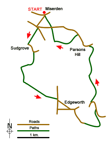
This circular Cotswolds walk in Gloucestershire starts from the estate village of Miserden with its attractive cottages built from mellow stone. The route continues to the hamlet of Sudgrove after which a section of pleasant woodland leads south to Edgeworth. The walk passed the fine parish church and manor before descending into the wooded Frome Valley. Continuing upstream the route passes Parson's Hill from where an ascent leads across fields back to the start.
Limited parking is available in the centre of Miserden village (grid ref. SO937089). After parking walk uphill out of the village keeping the Carpenters Arms on your right. After 350 metres you reach a road junction. Turn left, ignoring the lane unsuitable for heavy vehicles. Just before the house on the right, turn right onto a signed public footpath. Continue along the path to reach a lane in Sudgrove (grid ref. SO933080). Turn left along the lane and follow it as it bends to the right. Turn left at the next T-junction and then right onto the signed footpath. Follow the path keeping Sudgrove House on your right. Continue through the next field to the corner of Fox Wood (grid ref. SO934075).
The path continues downhill into pleasant woodland. Continue for just over 300 metres to reach a T-junction of tracks. Turn left and follows the right of way which runs above Holly Brook down to your right. The path swings to the left, exits the trees and continues to reach a road through wooden gates (grid ref. SO941066). Turn right along the road and almost immediately bear left along Ashletts Road into Edgeworth. You soon reach a junction with Farm Road where you turn left. Within a few metres bear right off Farm Road down a narrow lane signed to "the Church".
Walk past St. Mary's Church and immediately bear right onto a track keeping Edgeworth Manor to your left. Continue downhill to cross the River Frome. After crossing the river, the track bends to the left and continues through trees up to a lane (grid ref. SO952062). Turn left down the lane, cross the river at Brook Grove, ignore the first footpath off to the right, follow the road as it bends to the left and the turn right onto a signed bridleway 100 metres beyond the first signed path (SO950064).
Continue north up the Frome Valley for just over a kilometre to reach a road below Parson's Hill (grid ref. SO950080) where you turn left. Ignore the first footpath on the left and continue uphill for a further 250 metres and turn left onto a signed footpath (fingerpost hidden in the hedge on the right). Continue up the grassy path to reach a small rood where you bear right onto a track with trees on your right. The track swings away from the trees and within 100 metres turn right onto a path. The path crosses several fields, following the left-hand boundary, to reach a lane. Go straight across and follow the continuing path back to the start in Miserden.
Messaging & Social Media
Message Walking Britain and follow the latest news.

Mountain Weather
Stay safe on the mountains with detailed weather forecasts - for iOS devices or for Android devices.