Walk 3666 - printer friendly version
West Mendip Way & Old Ditch from Rodney Stoke Walk
Author - Lou Johnson
Length - 7.0 miles / 11.4 km
Ascent - 1000 feet / 303 metres
Grade - moderate
Start - OS grid reference ST484502
Lat 51.2486240 + Long -2.7406852
Postcode BS27 3XB (approx. location only)
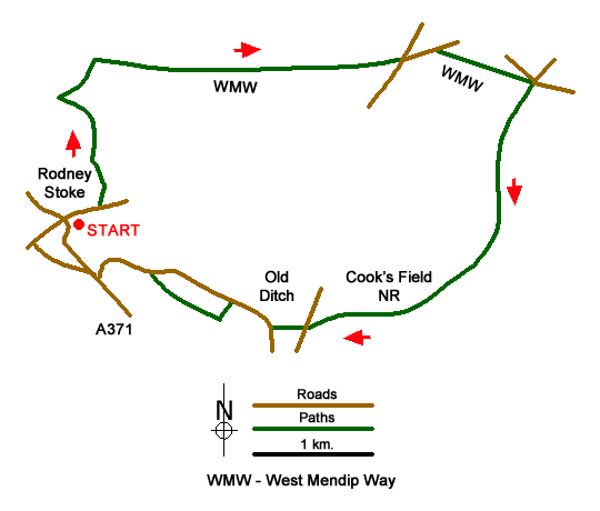
This Somerset walk in the Mendip Hills starts from Rodney Stoke on the A371 a few miles south east of Cheddar. The route starts with a climb through Stoke Woods to gain the high ground to Join the West Mendip Way, which is followed for 3 kilometres with wide ranging views towards Glastonbury. The walk continues descending through Cook's Field Nature Reserve to reach the hamlet of Old Ditch from where paths and lanes take you back to the start.
Parking in Rodney Stoke is limited. However, patrons can park at the Rodney Stoke Inn (grid ref. ST484502). After parking walk along the A371 into the village centre. Continue to where the road bends to the right. Turn left up a no-through road, Scadden's Lane, and follow the lane for about 350 metres to reach Wood Lane on the left. Turn into Wood Lane and almost immediately veer left off the lane to follow a footpath into trees and open ground (grid ref. ST490502). The path climbs steadily, enters woodland (Stoke Woods), and continues to climb to reach open hillside. Maintain direction to a hedge corner ahead. Continue ahead with hedge on your left to reach the West Mendip Way (grid ref. ST486513).
Turn right along the West Mendip Way. After a short climb you can enjoy a section of level walking with excellent views across the Somerset Levels to Glastonbury Tor, the Quantock Hills, Exmoor and across the Bristol Channel to Wales. After just over 2 kilometres of easy walking you reach a stile and Broad Road (grid ref. ST512513). Turn left and then immediately fork right. After 250 metres turn right onto the signed West Mendip Way across two fields to reach a gate onto another lane (grid ref. ST521511).
Do not go through the gate onto the lane but turn sharp right and follow the path with the field boundary on your left. After a kilometre of following the field edges, the path turns southwest and then descends through Cook's Field Nature Reserve. Exiting the Nature Reserve the route joins Little Field Lane which is followed down to Stancombe Lane (grid ref. ST505493). Turn left and almost immediately right onto a signed footpath. The path descends across fields to join Drapel Lane where you continue downhill to a T-junction.
Turn right and follow the road through Old Ditch. Just after passing the end of the 30-m.p.h. zone turn left onto a signed footpath which climbs onto Westclose Hill. At the top turn right and follow the path along the ridge and down to Westfield Lane (grid ref. ST492497). Turn left to reach the A371. With care cross the A371 to the lane opposite (Millway). Continue to a T-junction. Turn left along Stoke Street and then take the first lane on the right (Butts Lane) which leads back to the start.
Messaging & Social Media
Message Walking Britain and follow the latest news.

Mountain Weather
Stay safe on the mountains with detailed weather forecasts - for iOS devices or for Android devices.