Angle Tarn and Hayeswater from Patterdale
Lake District Walk
Nat Park - Lake District - Lake District Far Eastern Fells
County/Area - Cumbria
Author - Peter Smyly
Length - 8.3 miles / 13.5 km Ascent - 2000 feet / 606 metres
Time - 6 hours 10 minutes Grade - moderate
Walk Route Description
Click image to visit gallery of 6 images.
This circular Lake District walk from Patterdale features two Lakeland tarns but no summits although with a slight route digression, the Angletarn Pikes could be included as could The Knott. The route offers glorious walking and excellent scenery throughout.
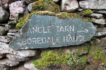
The start of the walk is the car park in Patterdale (grid ref. NY395159). Exit the car park and turn left along the main A 592 road. Turn first left along the minor road due north east between the Youth Hostel and the Patterdale Hotel. Cross the bridge over Goldrill Beck. Follow the road as it bends round to the left. Take the path through the gate on the right where a sign on a dry-stone wall indicates the way to Boredale Hause and Angle Tarn.
Continue along a gradually rising path that traverses the hillside in a south easterly direction leading to Boredale Hause, a col between Place Fell and the Angletarn Pikes. Boredale Hause represents a major route junction of footpaths, part of Wainwright's Coast to Coast route. From the collapsed marker cairn, cross a stream and take a path that leads to the south east and keep following the way ahead as it skirts round Angletarn Pikes on the left and leads to and past Angle Tarn with its islands and promontories, one of the more picturesque of the Lakeland Tarns. Angle Tarn was held in high regard by the late Lakeland author Alfred Wainwright.
The path drops slightly to skirt the tarn and continues on past it. Once the tarn is left behind continue below Satura Crag and across the flank of Rest Dodd. Before you reach The Knott, trend down to the right across pathless terrain to the outflow of Hayeswater. There is a path which can be picked up during the descent. A long and narrow body of water enclosed by mountains on three sides, Hayeswater is a very different tarn in appearance to Angle Tarn passed earlier in the walk. Good visibility should present no route-finding difficulties. According to Wikipedia, Hayeswater was restored to its natural tarn status in 2014 - the dam having been removed as it was not used as a reservoir since 2005.
Now continue the route by following the path downhill on the south side of the outflow of Hayeswater. Stay on the wide track, with the beck on your right, Hayeswater Gill, down to the village of Hartsop which is reached in around a mile. Continue through Hartsop and turn right on to the bridleway (grid ref. NY406132) which runs at valley level to Beckstones. Continue past Beckstones in a roughly northerly direction to reach the road used at the beginning of the walk. Continue ahead along the road which leads to Side Farm where a left turn takes you back to Patterdale and the start of the walk.
Maps 

| Ordnance Survey Explorer OL5 | Sheet Map | 1:25k | BUY |
| Anquet OS Explorer OL5 | Digital Map | 1:25k | BUY |
| Ordnance Survey Digital Map Subscription | |||
| Latest Ordnance Survey Discounts | |||
Other walks nearby
| Walk 1156 | Helvellyn via Striding Edge | hard | 9.5 miles |
| Walk 1235 | Red Tarn & Grisedale | moderate | 7.0 miles |
| Walk 1710 | Glenridding, St. Sunday Crag & Helvellyn | hard | 11.5 miles |
| Walk 3232 | Glenridding Dodd & Sheffield Pike | easy/mod | 4.5 miles |
| Walk 2327 | Red Tarn & Birkhouse Moor from Glenridding | moderate | 6.0 miles |
| Walk 3668 | Catstye Cam from Glenridding | mod/hard | 7.0 miles |
| Walk 1110 | Angletarn Pikes | moderate | 7.0 miles |
| Walk 2060 | The Angletarn Pikes and Brock Crags from Hartsop | moderate | 8.0 miles |
| Walk 3388 | Hayeswater and Angle Tarn from Hartsop | mod/hard | 11.5 miles |
| Walk 2386 | Red Screes via Dove Crag | mod/hard | 8.6 miles |
Recommended Books & eBooks
Walking the Lake District Fells - Buttermere
 Part of the Walking the Lake District Fells series, this guidebook covers a wide range of routes to 32 Lakeland summits that can be climbed from the Buttermere, Lorton and Newlands valleys, with highlights including Haystacks, High Stile, Grasmoor and the fells of the Coledale Round. Suggestions for longer ridge routes are also included.
More information
Walking the Lake District Fells - Keswick
 Part of the Walking the Lake District Fells series, this guidebook covers a wide range of routes to 30 Lakeland summits that can be climbed from Keswick, Whinlatter, Bassenthwaite, Caldbeck, Mungrisdale and Threlkeld, with highlights including Skiddaw and Blencathra. Includes suggestions for longer ridge routes.
More information
