Walk 3671 - printer friendly version
Nun's Cross & Peat Cot from Princetown Walk
Author - Lou Johnson
Length - 7.0 miles / 11.4 km
Ascent - 650 feet / 197 metres
Grade - easy/mod
Start - OS grid reference SX590735
Lat 50.5442200 + Long -3.9913616
Postcode PL20 6FG (approx. location only)
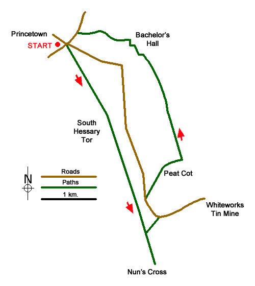
This Dartmoor walk starts from Princetown and explores the are south of the village. The route crosses the moor to reach Nun's Cross which was useful landmark for Medieval travellers. The walk continues to Nun's Cross Farm which was used as a location in one of Sir Arthur Conan Doyle's novels. From here a visit to the remains of Whiteworks Tin Mine after which the moorland walk continues past the lonely chapel at Peat Cot. Returning to Princetown across the moor the prison dominates the scene.
The start is the pay and display car park adjacent to the National Park Visitor Centre (grid ref. SX590735). After parking, exit the car park and turn right. Continue to mini roundabout. Go straight across and follow the bridleway to the left of the Plume of Feathers. This moorland track is then followed for 4 kilometres across South Hessary Tor to reach Nun's Cross (grid ref. SX605699). As you approach the Cross Nun's Cross Farm is a short distance down a track off to the left.
Retrace your steps along the bridleway used to reach Nun's Cross. 600 metres from the Cross, turn right at a junction of tracks. Continue straight ahead to a narrow lane (grid ref. SX605707) where you bear right to reach the remains of the disused Whiteworks Tin Mine. After exploring the site, walk back along the lane following it as it bends round to the right. Continue past the parking area (on your left) and after 200 metres bear half right onto a grassy track heading towards a few trees. Past between several fields to reach the Chapel at Stone Cot.
Just past the chapel, turn right and follow a grassy track keeping the wall on your left. After 300 metres the bridleway turns left and continues beside a wall (on your left) for just under two kilometres to reach Bullpark (grid ref. SX603773). Follow the track to the left with the house on your right. At the next junction turn right and follow a track towards Batchelor Hall. Just before reaching the hall, turn left onto a clear track and follow this to reach Two Bridges Road (grid ref. SX592737). Turn left and follow the road back to the start. If you wish you can turn right along the road to reach a viewpoint looking over the prison!
Messaging & Social Media
Message Walking Britain and follow the latest news.

Mountain Weather
Stay safe on the mountains with detailed weather forecasts - for iOS devices or for Android devices.