Walk 3722 - printer friendly version
Buckshott Fell & Sikehead Mines Walk
Author - Lou Johnson
Length - 6.5 miles / 10.6 km
Ascent - 750 feet / 227 metres
Grade - easy/mod
Start - OS grid reference NY964504
Lat 54.8483920 + Long -2.0575910
Postcode DH8 9SS (approx. location only)
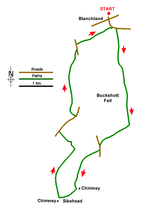
This County Durham walk explores the moors to the south of the attractive village of Blanchland (Northumberland) including the extensive remains of Sikehead Lead Mine. The route climbs steadily onto Buckshott Fell before heading south-west to Sikehead Mine where care should be taken when exploring the remains. From here the walks descends across Buckshott Moor before following a path through woodlands back to the start.
There is a free car park on the north side of Blanchland village (Grid ref. NY964504). After parking turn right out of the exit and walk to the main road through the village. Go straight across and take the road signed to Edmondbyers (B6306). Follow this road through the square with its rows of cottages. Cross the River Derwent and enter County Durham. At the first road junction (grid ref. NY967502) turn right and follow this road for 650 metres until it bends to the right (grid ref. NY968496).
Continue straight ahead through gate and follow the path uphill with a wall or fence to your left. After 1.5 km. you reach the top of the climb with a gate on the left (grid ref. NY970481). Turn right here following a track south-west which soon joins a road. Turn left and then after a short way turn right on to a track by a fingerpost (grid ref. NY964475). After 400 metres you reach a T-junction. Turn left aiming for the nearer chimney. Continue along the dam wall passing the first chimney which should be on your left. At the end of the dam wall, turn right and continue to the second chimney (grid ref. NY955464).
From here the route turns north turning right alongside a fence by the second chimney following the yellow waymark along a grassy track. This track curves left down to a wall junction (grid ref. NY953468). Turn right through a gate (yellow Waymark) and follow the wall downhill for 800 metres (wall on your left). Bear left downhill at another yellow waymark (grid ref. 958475) and head downhill to a gate into a plantation. Follow the waymarks downhill through the trees, then along a fenced path and through more trees to a road (grid ref. NY955479).
Turn right down the road for 500 metres and then turn left off the road (grid ref. NY958482) following the Pennine Journey long distance path. Continue downhill for 120 metres and then turn right to continue following the Pennine Journey. The route continues for 1.6 km. through trees to emerge at a road (grid ref. NY597497). Turn left downhill and after 150 metres turn right to continue following the Pennine Journey. Continue for a kilometre through trees to reach the B6306. Turn left and retrace your steps back to the start.
Messaging & Social Media
Message Walking Britain and follow the latest news.

Mountain Weather
Stay safe on the mountains with detailed weather forecasts - for iOS devices or for Android devices.