Walk 3732 - printer friendly version
Morston, Blakeney & Cley next the Sea Walk
Author - Lou Johnson
Length - 4.0 miles / 6.5 km
Ascent - 50 feet / 15 metres
Grade - easy
Start - OS grid reference TG006442
Lat 52.9576440 + Long 0.9850180
Postcode NR25 7BH (approx. location only)
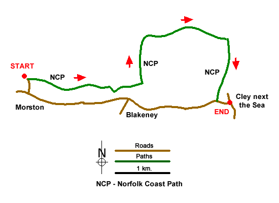
This short Norfolk costal walk from Morston follows the Norfolk Coast Path to Blakeney and Cley next the sea. The route makes use of the Coast Hopper bus service and allows you to explore three villages along the North Norfolk Coast. The walk offers views across the Morston Salt Marshes, abundant wildlife, and windmills. Refreshments are available in season in both villages.
The start is the National Trust car park at Morston Quay (Grid ref. TG006442). After parking, follow the Norfolk Coast Path west. This is signed to Blakeney from near the National Trust information Centre. The path follows a level course with the Morston salt Marshes on your left. These marshes provide a unique habitat and are home to a wide variety of birds. The houses of Blakeney are seen quite soon and with easy level walking you soon reach the village. Like Morston, Blakeney depended on the sea for its livelihood and even today the quay is busy with yachts and sailing boats.
Reaching Blakeney continue along the Norfolk Coast Path which is signed to Cley next the sea. Leaving the activity of the harbour behind, the path follows a raised dyke with salt marshes to your left and drained farmland to your right. Views are extensive with the tower of Blakeney Church and the windmill at Cley both prominent in this type of landscape. The path continues seaward but does not quite reach the shingle beach. An intervening channel containing the outflow of the River Glaven blocks further progress, and the route turns inland with this river on your left. Ahead the village of Cley and its dominant windmill are backed by low rolling hills. Nearing the village continue straight ahead to reach the A149 in the village.
Note - There is an excellent bus service operating along the A149 coast road between Sheringham and Kings Lynn. Operated by Norfolk County Council, this 'Coast Hopper' service is useful for many walks as the bus route shadows the Norfolk Coast Path. This enables one way walks to be undertaken with relative ease but also means that other walks can be altered to suit your needs.
Messaging & Social Media
Message Walking Britain and follow the latest news.

Mountain Weather
Stay safe on the mountains with detailed weather forecasts - for iOS devices or for Android devices.