Walk 3733 - printer friendly version
Coneysthorpe & Castle Howard from Welburn Walk
Author - Lou Johnson
Length - 9.0 miles / 14.6 km
Ascent - 650 feet / 197 metres
Grade - easy/mod
Start - OS grid reference SE721680
Lat 54.1028470 + Long -0.8988545
Postcode YO60 7EE (approx. location only)
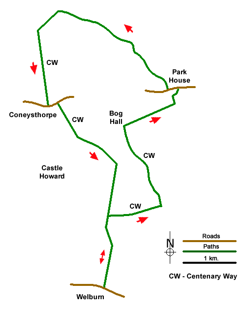
The Howardian Hills in North Yorkshire offer some excellent walking in pleasant scenery. This circular walk starts from the village of Welburn (North Yorkshire) with the route heading across the Castle Howard Estate to reach a wooded ridge with an ancient earthwork. The walk turns south through the estate village of Coneysthorpe before crossing parkland back to the start.
The start of the walk the main street of Welburn where on-street parking is available near the Crown & Cushion (grid ref. SE721680). From the pub turn left to Water Lane where you turn left into a lane which soon becomes a bridleway. Continue ahead for a kilometre to reach the Centenary Way (grid ref. SE723690). Bear left and follow the CW as it turns right. Continue for 250 metres and follow the CW as it turns right (grid ref. SE723693).
Follow the clear track for a kilometre and turn left at a sign for Coneysthorpe (grid ref. SE732694). After 140 metres turn left just past the large barn at Low Gaterly Farm. Continue along the clear track, still following the CW, for 1.5 kilometres to Bog Hall (grid ref. SE725709). Just past the large barn bear right signed to Easthorpe. Continue for a kilometre passing a small wood on your right. T the next junction continue ahead (grid ref. SE734713) signed to Park House and continue along a grassy track which curves around to reach a road (grid ref. SE733715).
Go straight across the road and up the driveway of Park House. After a short way go left through a gate to follow a bridleway (blue waymarks) which runs through trees along the escarpment edge. After a kilometre you reach a cross track (grid ref. SE727723) where you go straight across. Continue for a further 1.4 kilometres passing the trig point along the way. From here you can enjoy a fine view across the Vale of Pickering to the North York Moors. Reaching a fingerpost (grid ref. SE714729) bear left towards Coneysthorpe and re-join the CW. The bridleway leaves the trees and continues south to Coneysthorpe.
Turn left along the road and turn right through a gate in a wall (grid ref. SE713713). Follow the CW to Welburn along the track for 800 metres to reach the Great Lake on your left. Fork left by the gates and after 80 metres go right signed to Welburn (grid ref. SE719706). Continue through an area of scrub to join a track (grid ref. SE722705). Follow the track south to the Temple of Four Winds. Maintain direction and cross the New River Bridge (grid ref. SE724698). 600 metres beyond the bridge you re-join the outward route (grid ref. SE723693). From here retrace your steps back to the start.
Messaging & Social Media
Message Walking Britain and follow the latest news.

Mountain Weather
Stay safe on the mountains with detailed weather forecasts - for iOS devices or for Android devices.