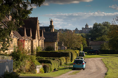
Coneysthorpe & Castle Howard from Welburn
Howardian Hills Walk
Region - Howardian Hills
County/Area - North Yorkshire - Howardian Hills
Author - Lou Johnson
Length - 9.0 miles / 14.6 km Ascent - 650 feet / 197 metres
Time - 5 hours 10 minutes Grade - easy/mod
Walk Route Description
Click image to see photo description.
The Howardian Hills in North Yorkshire offer some excellent walking in pleasant scenery. This circular walk starts from the village of Welburn (North Yorkshire) with the route heading across the Castle Howard Estate to reach a wooded ridge with an ancient earthwork. The walk turns south through the estate village of Coneysthorpe before crossing parkland back to the start.
The start of the walk the main street of Welburn where on-street parking is available near the Crown & Cushion (grid ref. SE721680). From the pub turn left to Water Lane where you turn left into a lane which soon becomes a bridleway. Continue ahead for a kilometre to reach the Centenary Way (grid ref. SE723690). Bear left and follow the CW as it turns right. Continue for 250 metres and follow the CW as it turns right (grid ref. SE723693).
Follow the clear track for a kilometre and turn left at a sign for Coneysthorpe (grid ref. SE732694). After 140 metres turn left just past the large barn at Low Gaterly Farm. Continue along the clear track, still following the CW, for 1.5 kilometres to Bog Hall (grid ref. SE725709). Just past the large barn bear right signed to Easthorpe. Continue for a kilometre passing a small wood on your right. T the next junction continue ahead (grid ref. SE734713) signed to Park House and continue along a grassy track which curves around to reach a road (grid ref. SE733715).
Go straight across the road and up the driveway of Park House. After a short way go left through a gate to follow a bridleway (blue waymarks) which runs through trees along the escarpment edge. After a kilometre you reach a cross track (grid ref. SE727723) where you go straight across. Continue for a further 1.4 kilometres passing the trig point along the way. From here you can enjoy a fine view across the Vale of Pickering to the North York Moors. Reaching a fingerpost (grid ref. SE714729) bear left towards Coneysthorpe and re-join the CW. The bridleway leaves the trees and continues south to Coneysthorpe.
Turn left along the road and turn right through a gate in a wall (grid ref. SE713713). Follow the CW to Welburn along the track for 800 metres to reach the Great Lake on your left. Fork left by the gates and after 80 metres go right signed to Welburn (grid ref. SE719706). Continue through an area of scrub to join a track (grid ref. SE722705). Follow the track south to the Temple of Four Winds. Maintain direction and cross the New River Bridge (grid ref. SE724698). 600 metres beyond the bridge you re-join the outward route (grid ref. SE723693). From here retrace your steps back to the start.
Maps 

| Ordnance Survey Explorer 300 | Sheet Map | 1:25k | BUY |
| Anquet OS Explorer 300 | Digital Map | 1:25k | BUY |
| Ordnance Survey Digital Map Subscription | |||
| Latest Ordnance Survey Discounts | |||
Other walks nearby
| Walk 3121 | Castle Howard & Coneysthorpe | moderate | 11.4 miles |
| Walk 3126 | Kirkham Priory & Pretty Wood from Low Hutton | moderate | 11.0 miles |
| Walk 1311 | Slingsby & South Holme | easy/mod | 8.0 miles |
| Walk 1990 | Settrington from North Grimston | easy/mod | 7.3 miles |
| Walk 1842 | Buttercrambe & Youlthorpe from Stamford Bridge | moderate | 11.8 miles |
| Walk 2703 | Thixendale & Kirby Underdale | easy/mod | 8.5 miles |
| Walk 1704 | Oswaldkirk, Nunnington & Harome circular | moderate | 11.5 miles |
| Walk 3515 | Deepdale and the deserted village of Wharram St. Percy | easy | 5.0 miles |
| Walk 3434 | North Grimston, Birdsall & Wharram Percy | moderate | 12.1 miles |
| Walk 1738 | The deserted village of Wharram St Percy | easy | 2.7 miles |
Recommended Books & eBooks
Trail and Fell Running in the Yorkshire Dales
 Guidebook to 40 of the best trail and fell runs in the Yorkshire Dales National Park. Ranging from 5 to 24 miles, the graded runs start from bases such as Ribblehead, Dent, Sedbergh, Malham and Grassington and take in the region's diverse delights, from castles and waterfalls to iconic mountains such as Whernside, Ingleborough and Pen Y Ghent.
More information
