Walk 3757 - printer friendly version
Buckland in the Moor Circular Walk
Author - Lou Johnson
Length - 6.3 miles / 10.2 km
Ascent - 1100 feet / 333 metres
Grade - easy/mod
Start - OS grid reference SX742761
Lat 50.5710610 + Long -3.7778323
Postcode TQ13 7TT (approx. location only)
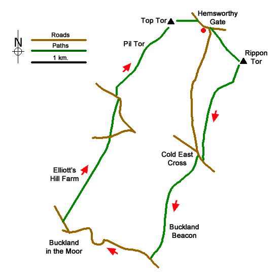
Starting from Hemsworthy Gate this Dartmoor walk explores open moorland, several rocky tors and passes through the attractive village of Buckland in the Moor with its fine parish church. The route follows paths and tracks across the moorland with some road walking. The views throughout the walk are excellent.
The start is the small car park at Hemsworthy Gate (grid ref. SX742761) on the B3387 east of Widdecombe in the Moor. After parking turn right and walk the short distance to the road junction. Bear left and pass through the gate on your right to join a clear path leading to the summit of Rippon Tor from where you can enjoy a wide view across the moors.
From the summit take the clear path down to gate at a wall junction (grid ref. SX746753). Follow the path with wall on your right and continue south to a gate and a road. Turn right to reach Cold east Cross. Turn left at the junction towards Buckland. Follow the road for 500 metres to a cattle grid (grid ref. SX7387138). Turn right off the lane and follow a path with a wall on your left to reach Buckland Beacon where you can enjoy a fine view south to the coast.
Continue ahead with the wall on your left and descend quite steeply down to a lane. Turn right along the lane for 1.5 kilometres to reach St. Peter's church in Buckland on the Moor. Opposite the church right into Elliott's Lane and continue to pass Elliott's Hill Farm on your right. Continue ahead onto a bridleway which crosses several fields. As you make progress north, you join a wider track which leads to a road (grid ref. SX727745). Go straight across to join a clear path/bridleway.
This bridleway soon reaches an enclosed field which is passes on your left. The route then follows the hedge on your left. Reaching a narrow lane, turn left and after 120 metres turn right onto a grassy track and follow the grassy path with a wall on your left. Follow the grassy path beside the wall for 800 metres to reach Tunhill Rocks. Head half right to the twin outcrops of Pil Tor from where you follow a path to reach the summit of Top Tor. It is worth spending a few minutes enjoying the view before following the clear path to east back to the start.
Messaging & Social Media
Message Walking Britain and follow the latest news.

Mountain Weather
Stay safe on the mountains with detailed weather forecasts - for iOS devices or for Android devices.