Walk 3760 - printer friendly version
Glamaig (Sgurr Mhairi & An Coileach) Walk
Author - Lou Johnson
Length - 4.5 miles / 7.3 km
Ascent - 2600 feet / 788 metres
Grade - mod/hard
Start - OS grid reference NG537314
Lat 57.3065020 + Long -6.0911011
Postcode IV48 8TD (approx. location only)
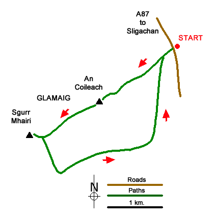
Glamaig is one of the outlying 'Red Hills' on the Island of Skye near Loch Sligachan. The highest and most northerly of the Red Cuillin with a grassy ride featuring which ends with summits at each end. Sgurr Mhairi is the highest (775 m.) at the southwestern end of the ridge with An Coileach (673 m.) at the north-eastern end. The hill has steep scree on the northern flank which discourages many from climbing the hill. The route described below avoids most of the scree which is only encountered in descent.
Park by the gate (grid ref. NG537314) on the west side of the A87 about 400 metres south of the road junction to Moll. Go through the gate and follow the fence uphill. The fence soon becomes a row of posts as you gain height. Continue until you climb above a rock outcrop from where you can more easily gain the ridge. You will be able to avoid most of the scree on grass or rock.
After gaining the summit of An Coileach, continue along the ride shadowing the row of fence posts. Where the fence bears left head straight to the summit of Sgurr Mhairi with its OS trig column. Continue ahead to a cairn which marks the best view. The panorama is dominated by Sgurr nan Gillean and the 'Black Cuillin'. In good visibility the view also includes the Outer Isles, Ben Nevis, the Trotternish ridge, the Isle of Raasay and Blabheinn.
Retrace you steps to the OS trig point and then bear half right down to the line of fence posts. Continue to the point where the fence bends left (grid ref. NG515299). From here head south-south-east down a steep slope towards Bealach na Sgairde. Continue down the scree to reach grassy ground at the bealach. Continue over easier ground in an easterly direction following trods on the northern side of the burn. As you approach the electricity poles the terrain becomes rougher. Follow the poles across the hillside to regain the outward route above the start.
Editor's Note This was my first Scottish hill after many years walking in the Lake District and Snowdonia (Eryri). The lack of paths, steepness of the hillside and the need to be reliant on maps all came into sharp focus. Despite this, it was an enjoyable ascent with the view from the summit more than compensating for the hard work.
Messaging & Social Media
Message Walking Britain and follow the latest news.

Mountain Weather
Stay safe on the mountains with detailed weather forecasts - for iOS devices or for Android devices.