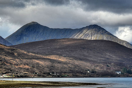
Glamaig (Sgurr Mhairi & An Coileach)
Highland Walk
County/Area - Highland - Isle of Skye
Author - Lou Johnson
Length - 4.5 miles / 7.3 km Ascent - 2600 feet / 788 metres
Time - 4 hours 50 minutes Grade - mod/hard
Walk Route Description
Click image to see photo description.
Glamaig is one of the outlying 'Red Hills' on the Island of Skye near Loch Sligachan. The highest and most northerly of the Red Cuillin with a grassy ride featuring which ends with summits at each end. Sgurr Mhairi is the highest (775 m.) at the southwestern end of the ridge with An Coileach (673 m.) at the north-eastern end. The hill has steep scree on the northern flank which discourages many from climbing the hill. The route described below avoids most of the scree which is only encountered in descent.
Park by the gate (grid ref. NG537314) on the west side of the A87 about 400 metres south of the road junction to Moll. Go through the gate and follow the fence uphill. The fence soon becomes a row of posts as you gain height. Continue until you climb above a rock outcrop from where you can more easily gain the ridge. You will be able to avoid most of the scree on grass or rock.
After gaining the summit of An Coileach, continue along the ride shadowing the row of fence posts. Where the fence bears left head straight to the summit of Sgurr Mhairi with its OS trig column. Continue ahead to a cairn which marks the best view. The panorama is dominated by Sgurr nan Gillean and the 'Black Cuillin'. In good visibility the view also includes the Outer Isles, Ben Nevis, the Trotternish ridge, the Isle of Raasay and Blabheinn.
Retrace you steps to the OS trig point and then bear half right down to the line of fence posts. Continue to the point where the fence bends left (grid ref. NG515299). From here head south-south-east down a steep slope towards Bealach na Sgairde. Continue down the scree to reach grassy ground at the bealach. Continue over easier ground in an easterly direction following trods on the northern side of the burn. As you approach the electricity poles the terrain becomes rougher. Follow the poles across the hillside to regain the outward route above the start.
Editor's Note This was my first Scottish hill after many years walking in the Lake District and Snowdonia (Eryri). The lack of paths, steepness of the hillside and the need to be reliant on maps all came into sharp focus. Despite this, it was an enjoyable ascent with the view from the summit more than compensating for the hard work.
Maps 

| Ordnance Survey Explorer 411 | Sheet Map | 1:25k | BUY |
| Anquet OS Explorer 411 | Digital Map | 1:25k | BUY |
| Ordnance Survey Digital Map Subscription | |||
| Latest Ordnance Survey Discounts | |||
Other walks nearby
| Walk 2002 | Dun Caan, Isle of Raasay | moderate | 10.6 miles |
| Walk 2589 | Marsco | moderate | 8.7 miles |
| Walk 3753 | Blabheinn via south ridge | mod/hard | 8.0 miles |
| Walk 3216 | Sgurr a'Ghreadaidh and Sgurr na Banachdich | very hard | 5.5 miles |
| Walk 2197 | The Inaccessible Pinnacle and Sgurr Mhic Choinnich | very hard | 6.0 miles |
| Walk 1167 | Glen Brittle & Coire Lagan | moderate | 4.6 miles |
| Walk 1166 | Loch Coruisk | easy | 4.0 miles |
| Walk 1164 | The Storr Sanctuary | easy/mod | 3.2 miles |
| Walk 2640 | The Storr & Old Man of Storr | moderate | 5.5 miles |
| Walk 1886 | Carn a' Bhealaich Mhoir | easy/mod | 8.0 miles |
Recommended Books & eBooks
Great Mountain Days in Scotland
 Inspirational guidebook to 50 challenging routes for mountaineers, scramblers, hillwalkers and fell runners, many long enough to backpack over 2 days, especially in winter (12 to 25 miles). A mix of classic routes and unsung gems across Scotland from Galloway to the Outer Hebrides in widely differing wild landscapes. With customised OS mapping.
More information
Walking the Munros Vol 2 - Northern Highlands and the Cairngorms
 Guidebook to walking the northern Munros, covering the northern Highlands, the Cairngorms and the Isle of Skye. 70 routes are described, including those up Ben Macdui, Braeriach and Cairn Gorm. Routes range from 7 to 46km, requiring a fair level of fitness. The second of two guidebooks to walking Scotland's Munros: peaks higher than 3000ft.
More information
