Aran Benllyn & Aran Fawddwy from Llanuwchllyn
Snowdonia/Eryri Walk
Nat Park - Snowdonia - Arans Lake Bala
County/Area - Gwynedd
Author - Lou Johnson
Length - 10.0 miles / 16.3 km Ascent - 3315 feet / 1005 metres
Time - 8 hours 20 minutes Grade - mod/hard
Maps 

| Ordnance Survey Explorer OL23 | Sheet Map | 1:25k | BUY |
| Anquet OS Explorer OL23 | Digital Map | 1:25k | BUY |
| Ordnance Survey Landranger 125 | Sheet Map | 1:50k | BUY |
| Anquet OS Landranger 125 | Digital Map | 1:50k | BUY |
Walk Route Description
Click image to see photo description.
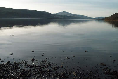
Although not an avid exponent of the out-and-back walk, this Snowdonia (Eryri) walk is good enough to justify inclusion. The picture below illustrates well what is in store with the route following the ridge from right to left and visiting all three peaks on the main Aran ridge.
The start is a small car park (Grid ref. SH879297) beside the Afon Twrch in the village of Llanuwchllyn at the southern end of Lake Bala. From the car park do not go over the bridge but take the track that heads south. This climbs gradually and after crossing a cattle grid follow the bridleway that forks to the right. Stay on this until it turns right and leave it to follow the signed footpath that leads onto the main Aran ridge.
The climb is steady and the path clear. As you climb you get ever improving views to your right with Arenig Fawr clearly in view. Beyond you may be able to see many of the other great mountains of northern Snowdonia (Eryri) including Snowdon itself. Eventually the path follows the ridge after shadowing for some way and you will find yourself gaining height more quickly as you ascend a couple of rocky steps in the ridge. Away to your left and far below is Llyn Lliwbran with the rounded hills of the Arans spread out beyond.
Eventually you will reach the summit of Aran Benllyn with its quartz speckled summit rocks adding a splash of colour to the scene. With one top 'ticked off' you can continue over Erw y Ddafad du, the lowest peak of the trio, to reach Aran Fawddwy. This is a super summit with a fine airy balcony on which to perch and enjoy the view. Having rested turn around and head back the way you came. Surprisingly you will see the Arans from a different perspective as you descend gently into the valley and return to the starting point.
Other walks nearby
| Walk 2059 | Castell Carndochan near Bala | easy/mod | 2.5 miles |
| Walk 2055 | Moel Emoel from near Bala | moderate | 6.0 miles |
| Walk 2937 | Aran Fawddwy northern approach | mod/hard | 8.4 miles |
| Walk 2811 | Rhobell Fawr and Ddualt from near Rhydymain | moderate | 8.5 miles |
| Walk 1499 | Rhobell Fawr and Dduallt from Llanfachreth | moderate | 12.0 miles |
| Walk 2302 | Arenig Fawr | moderate | 8.0 miles |
| Walk 1190 | Aran Fawddwy | mod/hard | 7.5 miles |
| Walk 3055 | Glasgwm | moderate | 4.5 miles |
| Walk 1255 | The Aran Ridge | hard | 11.2 miles |
| Walk 1400 | The Arans | hard | 14.0 miles |
Recommended Books & eBooks
Snowdonia: 30 Low-level and easy walks - South
 Guidebook describing 30 walks in Snowdonia, Wales. Routes are mostly low level and on clear paths and showcase the region's beautiful scenery and rich history and culture. Part of a 2-volume set, this southern volume includes Trawsfynydd, Bala, Dolgellau, Machynlleth, the Harlech Coast and the valleys of the Mawddach and Dyfi.
More information
The Cambrian Way
 Guidebook to the Cambrian Way, a challenging three-week mountain trek through Wales from Cardiff to Conwy. The 470km un-waymarked route is presented from south to north. Often sticking to long, beautiful ridgelines, it crosses wild and rugged terrain and visits many of Wales's highest mountains, including Snowdon.
More information
Messaging & Social Media
Message Walking Britain and follow the latest news.

Mountain Weather
Stay safe on the mountains with detailed weather forecasts - for iOS devices or for Android devices.