Hanbury Hall & Piper's Hill Circular
Worcestershire Walk
County/Area - Worcestershire
Author - Peter Lane
Length - 5.5 miles / 8.9 km Ascent - 440 feet / 133 metres
Time - 3 hours 10 minutes Grade - easy
Walk Route Description
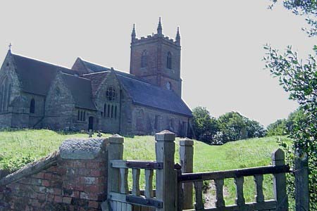
Click image to visit gallery of 6 images.
This easy walk involves very little climbing and is ideal for anyone wishing to take their first steps in using compass skills. The walk passes within a few metres of the delightful Hanbury Hall and crosses some typical rural Worcestershire countryside.
Park at Piper's Hill free car park (Grid ref. SO957652): not sign-posted from the road and slightly obscured by trees. Watch out for it on the west side of the B4091 (marked on Explorer map).
Descend towards the pond and head South through woods. Emerging from the woods turn slightly right and through a field (don't feed the horses!), up a hill to Hanbury Parish Church. Walk through the churchyard (take a moment to enjoy the expansive views of rural Worcestershire as this is the best viewpoint of the walk) and out through the main entrance onto the road. Go downhill for a few metres reaching a footpath on the left by which access to the Hanbury estate is gained. Proceed down the grassy slope towards the wooden gate in the distance. When the path forks into two tree-lined avenues, keep to the left one until the main access road to the Hall is reached.
Keeping the small pond ahead to your right, continue across a pathless field to a stile. Cross over and walk on past the Hall. Take a compass bearing of approximately 222 degrees and we'll see just how good your compass skills are! Head for the trees in the distance and if you've taken a good bearing, you'll end up on the left hand side of a small pond. Don't worry if you missed it (I hit the right side having taken a bearing on a cow!), just walk to the left side of the pond and locate the stile just beyond.
Cross over and immediately turn right down another footpath. Continue over a stile until reaching a complex double stile. Don't cross here but turn left and follow the field boundary to a gap in the hedge where a footbridge affords access to the other side of the hedge. Cross over and take another compass bearing of 310 degrees. Resist the temptation to follow the line of the woods. Good compass work will take you past a small pond in a hollow at the top of the hill. From there head down to a metal gate and a wide farm access.
At the bottom of the hill, cross a stile into the farmyard and follow the waymarks on the stiles to the North of Summerhill farm, reaching a bridge over the canal. Here you face a choice: cross a gate with barbed wire on top to gain direct access to the tow-path, or cross the bridge and continue on the footpath.
If crossing the bridge, the footpath continues until it crosses a bridlepath to Walmer farm. Take the footpath from the farm going right, under the railway, back to the canal and cross the canal on the lock gates (handrail provided).
Either way, head North on the tow-path until just after Astwood Lane bridge. Locate a stile leading east across fields. Follow the field boundary across stiles and footbridges until reaching a country lane. Here turn right and then in a few metres find a footpath on the left. Continue roughly Eastwards following the boundary hedges. Once near the end of one field, the path goes through a gap in the hedge, crossing a stream via a concealed footbridge and continuing on the left hand side.
Eventually reach the outward footpath at Piper's Hill and retrace the last few hundred metres back to the car park.
Maps 

| Ordnance Survey Explorer 204 | Sheet Map | 1:25k | BUY |
| Anquet OS Explorer 204 | Digital Map | 1:25k | BUY |
| Ordnance Survey Digital Map Subscription | |||
| Latest Ordnance Survey Discounts | |||
Other walks nearby
| Walk 3472 | Tardebigge Flight of Locks, Bromsgrove | easy | 5.3 miles |
| Walk 3715 | Holberrow Green & New End from Inkberrow | easy/mod | 8.3 miles |
| Walk 3226 | New End & Holberrow Green from Inkberrow | easy/mod | 8.0 miles |
| Walk 3686 | Dormston from Inkberrow Circular | easy | 5.4 miles |
| Walk 3684 | Flyford Flavell and Dormston circular | easy | 4.5 miles |
| Walk 3681 | New End & Cladswell Circular | easy | 3.5 miles |
| Walk 3680 | Broughton Hackett and Upton Snodsbury | easy | 3.0 miles |
| Walk 1501 | Lickey Hills, Barnt Green and the Bittell Reservoirs | easy | 4.5 miles |
| Walk 2313 | Upton Snodsbury Circular | easy/mod | 7.5 miles |
| Walk 1830 | Ombersley, the Droitwich Canal, Salwarpe & the Severn | easy/mod | 11.0 miles |
